Firbeix
| Firbeix | ||
|---|---|---|
|
|
||
| region | Nouvelle-Aquitaine | |
| Department | Dordogne | |
| Arrondissement | Nontron | |
| Canton | Thiviers | |
| Community association | Périgord-Limousin | |
| Coordinates | 45 ° 36 ′ N , 0 ° 59 ′ E | |
| height | 290-451 m | |
| surface | 22.66 km 2 | |
| Residents | 307 (January 1, 2017) | |
| Population density | 14 inhabitants / km 2 | |
| Post Code | 24450 | |
| INSEE code | 24180 | |
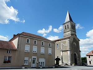
 Firbeix Church Square |
||
Firbeix , Occitan Firbes is a commune with 307 inhabitants (at January 1, 2017) of the North department Dordogne in the region Nouvelle-Aquitaine . It belongs to the Arrondissement of Nontron and the Canton of Thiviers . It also forms part of the Périgord-Limousin Regional Nature Park .
etymology
The Occitan Firbes is derived from the Latin finis , more precisely from the dative plural finibus , meaning border or edge . What is meant here is the border between the Limousin and the Périgord .
geography
Firbeix is six kilometers south of Châlus and six kilometers north of La Coquille (as the crow flies).
The municipality is surrounded by the following neighboring municipalities:
- Dournazac ( Haute-Vienne ) in the north.
- Bussière-Galant (Haute-Vienne) in the northeast.
- Saint-Pierre-de-Frugie to the east.
- La Coquille in the south.
- Mialet to the southwest and west.
At 451 meters, the municipality of Firbeix is the second highest municipality in the Dordogne department after Saint-Pierre de-Frugie. It is also a border municipality to the Haute-Vienne department in the north and northeast. In addition to the very asymmetrical town center in the northeast, the municipal area includes numerous hamlets, farms, two mansions, a castle and a forge:
Bellevue-les-Vignes , Boursaneix , Chantegros , Coupiat , Durdreix , Gourso (l) las , Jambe de Banc , La Chabrerie , La Forge , La Jourde , La Lande , Lavaud , Le Barrat , Le Bost , Le Château de Firbeix , Le Châtenet , Le Dognon , Le Gadonnet , Le Laurier , Le Mas Goudier , Le Passage , Les Bordes , Les Pouyades , Matibois , Montchapeix , Pauliac , Puiffe , Puissechien , Puybernard and Puyregonde .
The entire northern border of the municipality of Firbeix is formed by the east-west flowing Dronne . At the southeast corner east of the hamlet of Le Châtenet which is the headwaters of the Côle . It takes a south course and is dammed up into several smaller ponds. Then it leaves the municipality in a south-westerly direction and at the same time defines the border with La Coquille. Not far northwest of the source of the Côle, the Coly rises near Goursollas . It moves to the west-southwest towards the municipality of Mialet.
The topographically lowest point of the municipality with 290 meters above sea level is on the Dronne in the northwest; the highest point at 451 meters is on the northeast corner at Les Pouyades .
geology
The municipality of Firbeix lies entirely on metamorphic basement rocks of the northwestern Massif Central . Mainly these are eye gneisses of the lower gneiss cover . To the east of the town center, plagioclase- bearing paragneiss are still open. The eye gneisses are not homogeneous, but can be roughly divided into three series - ordinary eye gneisses at the base, followed by very massive eye gneisses (former metagranites ) and leptynite eye gneisses (former rhyodacites and rhyolites ) in the hanging wall. As a curiosity, the Augengneise contain two island-like occurrences of structurally deeper mica schists of the parautochthonous mica schist unit along the western border (south of Durdreix and west of Les Bordes ). The southeastern part of the parish is traversed by the northeast-southwest trending La Coquille Fault Zone , which can in part take on mylonite character. In addition to local offsets, it causes the generally NNW-SSE-striking foliation of the gneisses to bend in the northeast direction.
The basement is covered in places by a relatively thin colluvium of the Pleistocene . Recent alluvium can be found in the Dronnetal .
history
Remains from the Gallo-Roman era have been found in Firbeix . Firbeix could be identified as the station Fines on the Peutinger tablets of late antiquity . In the 17th century , two mansions were built, the Manoir de Coupiat and the Manoir de Goursolas . The Château de Firbeix dates from the 18th century . The local church of Saint-Étienne was only built in the 19th century .
Population development
| Population development in Firbeix | ||||
|---|---|---|---|---|
| year | Residents |

|
||
| 1962 | 553 | |||
| 1968 | 510 | |||
| 1975 | 448 | |||
| 1982 | 401 | |||
| 1990 | 364 | |||
| 1999 | 322 | |||
| 2008 | 331 | |||
| 2016 | 306 | |||
Source: INSEE
Attractions
- Manoir de Coupiat, 17th century manor house
- Manoir de Goursolas, also from the 17th century
- 18th century Château de Firbeix
- Saint-Etienne church from the 19th century
Transport links
Firbeix is located directly on the RN 21 from Limoges to Périgueux . Coming from Bussière-Galant, a municipal road crosses the town center in an east-west direction. It then leads to the D 77 (Mialet - Pensol or La Chapelle-Montbrandeix ). The D 82 from Saint-Pierre-de-Frugie to Mialet crosses the southern part of the municipality.
Individual evidence
literature
- Briand, B. et al .: Feuille Châlus . In: Carte géologique de la France à 1/50000 . BRGM.
- Dominique Richard (Ed.): Le Guide Dordogne-Périgord. Éditions Fanlac, Périgueux 1993, ISBN 2-86577-162-8 .

