
La Chapelle-Montbrandeix
| La Chapelle-Montbrandeix | ||
|---|---|---|
.svg)
|
|
|
| region | Nouvelle-Aquitaine | |
| Department | Haute-Vienne | |
| Arrondissement | Rochechouart | |
| Canton | Rochechouart | |
| Community association | Ouest Limousin | |
| Coordinates | 45 ° 39 ′ N , 0 ° 51 ′ E | |
| height | 319-482 m | |
| surface | 19.83 km 2 | |
| Residents | 256 (January 1, 2017) | |
| Population density | 13 inhabitants / km 2 | |
| Post Code | 87440 | |
| INSEE code | 87037 | |

La Chapelle-Montbrandeix , in Occitan La Chapela e Mont Brandés , is a municipality in the Périgord-Limousin Regional Nature Park in France . It belongs to the Nouvelle-Aquitaine region , the Haute-Vienne department , the Rochechouart arrondissement and the Rochechouart canton . It borders in the north on Cussac , in the northeast on Champagnac-la-Rivière (point of contact), in the east on Dournazac , in the southeast on Mialet, in the southwest on Pensol and in the west on Marval.
The Via Lemovicensis , one of the four historical “ Routes of the Pilgrims of St. James in France ”, leads through La Chapelle-Montrandeix.
Population development
| year | 1962 | 1968 | 1975 | 1982 | 1990 | 1999 | 2008 | 2013 | 2015 |
|---|---|---|---|---|---|---|---|---|---|
| Residents | 452 | 412 | 352 | 333 | 293 | 262 | 252 | 251 | 248 |
Attractions
- Les Couvents , remains of a Gallo-Roman blast furnace

"Gisement gallo-romain des couvents les Varognes", remains of a Gallo-Roman blast furnace near La Chapelle-Monbrandeix, today a monument historique
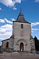
The church of La Chapelle-Montbrandeix

