
Javerdat
|
Javerdat Javerdac |
||
|---|---|---|
.svg)
|
|
|
| region | Nouvelle-Aquitaine | |
| Department | Haute-Vienne | |
| Arrondissement | Rochechouart | |
| Canton | Saint-Junien | |
| Community association | Porte Océane du Limousin | |
| Coordinates | 45 ° 57 ' N , 0 ° 59' E | |
| height | 228–336 m | |
| surface | 25.52 km 2 | |
| Residents | 717 (January 1, 2017) | |
| Population density | 28 inhabitants / km 2 | |
| Post Code | 87520 | |
| INSEE code | 87078 | |
 Saint Blaise Church and Town Hall (Mairie) of Javerdat |
||

Javerdat ( Occitan : Javerdac ) is a commune with 717 inhabitants (at January 1, 2017) in the department of Haute-Vienne in the region Nouvelle-Aquitaine . It belongs to the arrondissement of Rochechouart and the canton of Saint-Junien (until 2015 canton of Saint-Junien-Est ) and is a member of the Vienne Glane community .
geography
Javerdat is about 25 kilometers northwest of Limoges . Javerdat is surrounded by the neighboring communities of Montrol-Sénard in the north, Cieux in the north and northeast, Oradour-sur-Glane in the east and southeast, Saint-Brice-sur-Vienne in the south, Brigueuil in the west and Montrollet in the north-west.
Population development
| year | 1962 | 1968 | 1975 | 1982 | 1990 | 1999 | 2006 | 2013 |
| Residents | 624 | 591 | 559 | 555 | 528 | 523 | 600 | 711 |
| Source: Cassini and INSEE | ||||||||
Attractions
- Rouffignac dolmen
- Menhir du Pic
- Saint Blaise Church

Rouffignac dolmen
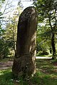
Menhir du Pic


Web links
Commons : Javerdat - collection of images, videos and audio files