
Marval
| Marval | ||
|---|---|---|
.svg)
|
|
|
| region | Nouvelle-Aquitaine | |
| Department | Haute-Vienne | |
| Arrondissement | Rochechouart | |
| Canton | Rochechouart | |
| Community association | Ouest Limousin | |
| Coordinates | 45 ° 38 ′ N , 0 ° 48 ′ E | |
| height | 245-476 m | |
| surface | 38.5 km 2 | |
| Residents | 540 (January 1, 2017) | |
| Population density | 14 inhabitants / km 2 | |
| Post Code | 87440 | |
| INSEE code | 87092 | |
 Marval town center with Saint-Amand church |
||

Marval , Occitan Marvau is a French village with 540 inhabitants (at January 1, 2017) in the Haute-Vienne in the region Nouvelle-Aquitaine (before 2016 Aquitaine ). It belongs to the Arrondissement of Rochechouart and the Canton of Rochechouart . The responsible community association is the Communauté de communes Ouest Limousin . The inhabitants are called Marvalais or Marvalaises .
geography
Marval is a border municipality to the Dordogne department and is surrounded by the following 6 neighboring municipalities:
| Saint-Mathieu | Saint-Mathieu | Cussac |
| Saint-Barthélemy-de-Bussière (Dordogne) |
.svg)
|
La Chapelle-Montbrandeix |
| Abjat-sur-Bandiat (Dordogne) | Pensol |
It is 43 kilometers to the prefecture town of Limoges in the northeast .
The municipality of Marval includes the following hamlets, farmhouses, castles, a forge, mills and landmarks: Beaufet, Beautarias, Béchégut, Bois de la Faurie, Bois de la Faye, Bois de la Lisonne, Bois de la Planche, Bras Court, Carreau, Château Ballerand, Chez Coutaud, Forêt du Puy Chevalier, Forêt Haute, Haut Jardin, L'Age, L'Épinassie, La Chautrandie, La Faurie, La Faye, La Forge de l'Épinassie, La Fosse, La Grande Pièce, La Lardie, La Lisonne, La Molle, La Nadalie, La Rodière, La Rue, La Souchère, La Touyère, La Varlanchie, La Vigne, La Vilotte, Laborie, Labrousse, Lafarge, Lafont Boudoire, Lampon, Larmat, Lascaux, Lavaud, Le Châtenet, Le Clos de l'Étang, Le Courtieux, Le Coux, Le Fayart, Le Grand Vernet, Le Masbertier, Le Mazelier, Le Moulin de Saint-Auvent, Le Moulin de la Chautrandie, Le Moulin du Theillaud, Le Petit l'Age, Le Petit Vernet, Le Plantadis, Le Puy, Le Puy Chalard, Le Puy Chevalier, Le Puypacaux, Le Theillaud, Le Theillet, Le Vancannaud, Le Vignaud, Les Brugeaux, Les Ch aralles, Les Chardreaux, Les Fougères, Les Maunias, Les Montades, Les Quatre Vents, Les Rivauds, Leyrat, Libre Oreille, Loubeyrat, Milhaguet, Montfrebœuf, Moulin de Masbertier, Mouriol, Sainte-Catherine, Terrasson, Trancord, Vaubrune and Vitrac .

The topographically lowest point at 245 meters above sea level is on the Bandiat on the southwest border, the highest point at 476 meters is in the Monts de Châlus near La Souchère on the northeast border. The maximum height difference is 231 meters.
The once independent parish of Milhaguet became part of Marval in 1973.
With 38.5 square kilometers, Marval is a very large municipality, but can only have a very low population density of 14 inhabitants / km².
Transport links
The municipality of Marval is located away from major traffic axes. Via the D 15 - in an easterly direction to Pensol and Les Trois Cerisiers - the town center has a connection to the D 85 or D 6 b from Nontron to Châlus . In a westerly direction, Piégut-Pluviers is reached via the D 15 . The D 67 connects Marval with Saint-Mathieu in the north-northwest. The D 64 leads to the neighboring town of La Chapelle-Montbrandeix in the northeast and on to Dournazac . To the south, the D 64 connects to Abjat-sur-Bandiat and then continues to Nontron via the D 87. The D 73 from Saint-Barthélemy-de-Bussière to Cussac crosses through Milhaguet in a north-easterly direction.
Long-distance hiking trail
The GR 4 long-distance hiking trail runs from Royan to Grasse through the south-east of the municipality .
Hydrography
The north of the municipality of Marval belongs to the catchment area of the Trieux with its left branch Ruisseau de la Chautrandie . The southern part drains in the direction of Bandiat, which drains to the southwest in the direction of Nontron . Before leaving the municipality, the bandiat is dammed up to the Étang de Ballerand .
geology

The municipality of Marval lies entirely on the crystalline, Variscan basement of the north-western Massif Central , which forms a bulge here - the Saint-Mathieu-Dom . The cathedral structure is characterized by the Saint-Mathieu leukogranite , which penetrated into the mica slate of the parautochthonous mica slate unit in the Upper Carboniferous . In the southwest the Piégut-Pluviers-Granodiorit is still pending - mainly in its coarse-grained normal facies, but around the Étang de Ballerand also in red, aplitic porphyry facies . The contact zone between the two granitoids is designed as fine-grain facies on both sides and runs right through the center of the village.
The mica schist appear in small, isolated, partly westvergent folded occurrences within the Leukogranits at Le Courtieux , La Lardie , Le Mazelier and La Vilotte and contiguous to the southeast to Le Theillaud and northeast to Larmat . They have been changed contact-metamorphically by the leucogranite (appearance of cordierite ). Their regional degree of metamorphosis corresponds to the albite and oligoclase zones . The foliation of the mica schist sweeps north to north-northeast and falls with 40 to 60 ° to the east one, stretching Linear on the foliation plane show predominantly east-southeast gen. In the northern section near Larmat , the foliation swings in the north-northwest direction.
Courses of micro granite by pulling the two Granitoids with predominantly north-west to north-westerly direction of strike . The leuco granite is affected east of the town center by a north-north-east trending fault series . Also worth mentioning are two lamprophyre veins in the leuco granite near L'Age in north-north-east and north-north-west directions.
ecology
The municipality of Marval is an integral part of the Périgord-Limousin Regional Natural Park .
history
As the remains of an oppidum show, the municipality of Marval was settled since the Gallo-Roman era . The Church of the Assumption in Milhaguet was probably built in the 12th century. The Saint-Amand church in Marval dates back to the 13th century.
Population development
| Population development in Marval | ||
|---|---|---|
| year | Residents |

|
| 1962 | 1056 | |
| 1968 | 914 | |
| 1975 | 783 | |
| 1982 | 683 | |
| 1990 | 556 | |
| 1999 | 553 | |
| 2004 | 564 | |
| 2008 | 579 | |
| 2009 | 587 | |
| 2013 | 566 | |
| 2014 | 557 | |
| 2017 | 540 | |
Source: INSEE
The population of the municipality of Marval has generally declined since 1962 (population loss of 49 percent), with a slight trend reversal between 1999 and 2009.
mayor
Mayor of Marval has been the non-party pensioner Lucien Pot since October 2008.
Attractions
- Marval Castle, Monument historique
- Saint-Amand Church, Monument historique
- Church of the Assumption in the Milhaguet district
- The Ballerand domain
- The rock monolith Boisseau de dîmes ( Tenth Sheep )
Photo gallery
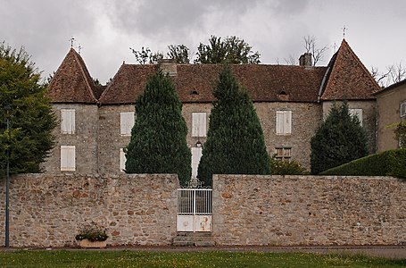 Marval Castle
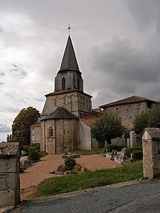 Saint-Amand church
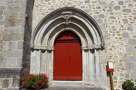 Entrance portal of Saint-Amand
 The boisseau des dîmes
 View of Milhaguet
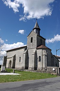 Church of the Assumption in Milhaguet
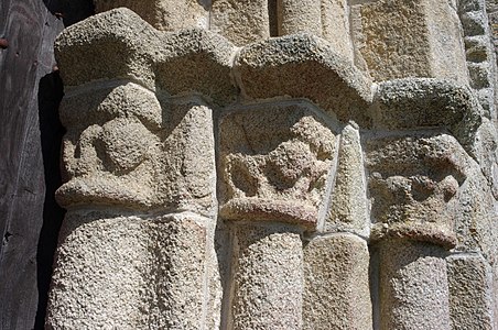 Capitals of the portal columns of the Assumption
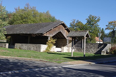 Marval wash house


literature
- B. Briand et al. a .: Feuille Châlus . In: Carte géologique de la France at 1/50 000 . BRGM.