
Piégut-Pluviers
| Piégut-Pluviers | ||
|---|---|---|

|
|
|
| region | Nouvelle-Aquitaine | |
| Department | Dordogne | |
| Arrondissement | Nontron | |
| Canton | Périgord Vert Nontronnais | |
| Community association | Périgord Nontronnais | |
| Coordinates | 45 ° 37 ′ N , 0 ° 41 ′ E | |
| height | 216-310 m | |
| surface | 18.11 km 2 | |
| Residents | 1,166 (January 1, 2017) | |
| Population density | 64 inhabitants / km 2 | |
| Post Code | 24360 | |
| INSEE code | 24328 | |
 View from the tower over Piégut to the east |
||

Piégut-Pluviers , Occitan Puei 'good e Pluviers , is a French municipality with 1166 inhabitants (at January 1, 2017) in the department of Dordogne in the region Nouvelle-Aquitaine (before 2016: Aquitaine ). It belongs to the Arrondissement of Nontron and the canton of Périgord Vert Nontronnais (until 2015: Canton of Bussière-Badil ). The responsible community association is the Communauté de communes du Périgord Nontronnais . The inhabitants are called Piégutains or Piégutaines .
etymology
The place was called "Podium Acutum" in Gallo-Roman times. The Latin name then changed from “Puy-Agu” (pointed mountain top) to “Piégut”.
geography

The municipality of Piégut-Pluviers is 45 kilometers from Angoulême and 65 kilometers from Périgueux .
The following 6 neighboring municipalities surround the municipality of Piégut-Pluviers:
| Busserolles | Champniers-et-Reilhac | Saint-Barthélemy-de-Bussière |
| Saint-Estèphe |
.svg)
|
|
| Saint-Estèphe | Augignac | Abjat-sur-Bandiat |
In the municipality there are numerous districts, hamlets, isolated farms, mills and landmarks such as Bois de Puyrocher , Bost Gaillou , Cabaniers , Château de Puyrazeaud , Chez Noyer , La Bonnefond , La Domèze , La Folie , La Lègue , La Maison Blanche , La Malignie , La Noche , La Nosilière , La Renaudie , La Tricherie , La Vigne , Lascaud , Lauterie , Le Cluzeau , Le Moulin de Chez Noyer , Les Champs Fleuris , Les Granges , Les Touilles , Luclas , Montagut , Pluviers , Prieuraud , Puygaud , Soulagnieux , Tous Vents and Villefaix .
The topographically lowest point at 216 meters is on the Trieux in the northeast, the highest point at 310 meters is south of Cabaniers in the west. The absolute height difference is 94 meters. The center of Piégut is at 283 meters, Pluviers at 268 meters above sea level.
Transport links

Via the D 675 , the municipality of Piégut-Pluviers is connected to Nontron in the south and Saint-Mathieu in the Haute-Vienne department to the north. Further, the D crosses 91 of Marval according to the west in the Charente located Montbron . The D 91 E3 connects them with Le Bourdeix in the southwest.
Long-distance hiking trail
The GR 4 long-distance hiking trail from Royan to Grasse crosses the west of the municipality coming from Busserolles and then crosses over to Saint-Éstephe.
Hydrography
Only two rivers pass through the municipality, the Ruisseau de l'Étang Grolhier and the Trieux , both of which drain to the northwest. The Trieux forms the northeast border to the municipalities of Champniers-et-Reilhac and Saint-Barthélemy-de-Bussière. There are countless smaller, man-made ponds and reservoirs; the largest of them, the Étang Grolhier , is a bird sanctuary.
geology

The municipality of Piégut-Pluviers is completely underlain by the Upper Carboniferous Piégut-Pluviers granodiorite , which occurs here mainly with its coarse-grained normal facies γ 3M . This approximately 250 square kilometers large granodiorite massif was named after its type locality Piégut-Pluviers. Its fine-grained facies f γ 3M appear in small, isolated occurrences near Lauterie , Luclas , Montagut and Villefaix .
Several persistent faults pervade the granodiorite. Their typical Variscan strike directions form a conjugate system of north-northwest and north-northeast plus the east direction.
Same directions also follow courses of micro granite ( microns .gamma. ) at La Legue , Les Granges and Tous Vents (north-northeast) and in the extreme southwest south of Prieuraud (north-northwest). The micro-granite veins at La Noche and east of Pluviers strike north. At the northern end of the Piégut quarry there is an extremely rare north-northeast trending lamprophyre vein - so far the only find in granodiorite.
The granodiorite was formerly a very popular, decorative building block for door and window lintels and was mined in the quarries of Piégut and Lacaujamet (municipality of Saint-Estèphe). In the meantime, however, these activities have come to a standstill.
ecology

Natural park
The municipality of Piégut-Pluviers has been part of the Périgord-Limousin Regional Nature Park since 1998 (and reaffirmed in 2011) .
Protected areas
The valleys of the Trieux in the northeast of the municipality and the Ruisseau de l'Étang Grolhier in the northwest form an ecological protection zone of continental type 1, which is known in French as ZNIEFF - zone naturelle d'intérêt écologique, faunistique et floristique . It belongs to the "Vallées du réseau hydrographique de la Tardoire et du Trieux" (valleys of the hydrographic network of Tardoire and Trieux), which are characterized by their remarkable flora and water quality. Of the 40 or so plant species, four taxa are considered characteristic: musk herb ( Adoxa moschatellina ), fingered lark spur ( Corydalis solida ), rue mussel flowers ( Isopyrum thalictroides ) and Atlantic hare bells ( Hyacinthoides non-scripta ).
In the north of Pluviers, the municipalities of Piégut-Pluviers (around 7.5 hectares), Champniers-et-Reilhac (around 4.2 hectares) and Busserolles (around 10.7 hectares) share the Étang Grolhier , which has been a site naturel since 1979 inscrit is under nature protection.
history

The first traces of settlement go back to the Neolithic (finds at the Butte du Collège ), and the Iron Age is also documented (remains of the wall near Puygaud and Maine du Bos ). In the vicinity of the hamlet of Chez Noyer you can still make out a 2 meter wide Roman road , accompanied by ditches, and a Gallo-Roman smithy was once located here .
In the district of Pluviers , the construction of a Romanesque church began in the 12th century, which was modified in the 15th century and finally in the 19th century.
A heavily fortified castle complex was built on a hill in the granodiorite in the Piégut district in the 12th century , but it was destroyed in 1199 by Richard the Lionheart . In addition to the remains of the wall, only the 23-meter-high round tower remains from this complex.
In the 15th century, the Seigneurie Piégut (Puy-Agu), which was dependent on Limoges, existed in Piégut.
The previously independent communities of Piégut and Pluviers merged in 1862 to form Piégut-Pluviers .
Population development
| Population development in Piégut-Pluviers | |||
|---|---|---|---|
| year | Residents |

|
|
| 1962 | 1558 | ||
| 1968 | 1545 | ||
| 1975 | 1504 | ||
| 1982 | 1527 | ||
| 1990 | 1471 | ||
| 1999 | 1313 | ||
| 2005 | 1215 | ||
| 2008 | 1216 | ||
| 2010 | 1227 | ||
| 2013 | 1226 | ||
| 2016 | 1174 | ||
| 2017 | 1166 | ||
The population of Piégut-Pluviers (in contrast to France) is generally declining, strong since 1990, had stabilized since 2005 and has been dwindling again since 2013.
With an area of 18.11 square kilometers, the population density is 64 inhabitants / km². The municipality of Piégut-Pluviers has the third highest population after Nontron and Saint-Pardoux-la-Rivière and the second highest population density in the canton of Périgord Vert Nontronnais after Nontron.
mayor
Mayor of Piégut-Pluviers has been Alain Marzat since September 2016.
Economy
employment
In 2012, the working age population aged 15 to 64 was 438; this corresponds to 35.2% of the total population. The number of unemployed has increased from 40 to 47 in 2007, and the unemployment rate is now 10.6%.
Companies
As of December 31, 2013, the municipality of Piégut-Pluviers had 151 companies, 92 of which were in the trade, transport and services sector, 22 in construction, 20 in administration, education, health and social affairs, 15 in industry and 2 in agriculture , Forests and fisheries.
Attractions

- The Piégut Tower, a round donjon made of local granodiorite , part of a fortification that was destroyed by Richard the Lionheart in 1199 . However, the tower was preserved.
- The 12th century Romanesque church of Saint-Étienne in Pluviers
- The Notre-Dame-de-la-Nativité church in Piégut
Events
Every Wednesday morning since 1642 there has been a regionally important weekly market in Piégut-Pluviers.
On June 30th and July 1st 2012, the 93rd Félibrée was held in Piégut-Pluviers , the great Occitanian festival that takes place once a year at the beginning of summer in a municipality in the Dordogne.
Personalities
- Pierre-Philippe Niocel (1833–1909), mathematician and educator
Photo gallery
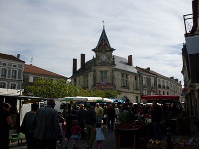 Weekly market in front of the Mairie
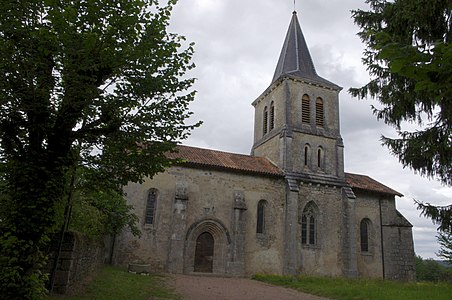 The Saint-Etienne church in Pluviers
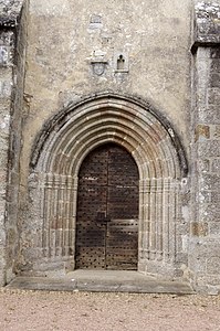 Entrance portal of Saint-Etienne
 The tower of Piégut
 The fortification from the inside
 Fireworks at the tower of Piégut
 Stained glass window in Notre-Dame-de-la-Nativité


Individual evidence
- ↑ INSEE: Population development of Piégut-Pluviers 1962-1999 ( page no longer available , search in web archives ) Info: The link was automatically marked as defective. Please check the link according to the instructions and then remove this notice.
- ^ INSEE: Results of the surveys 2004, 2005 and 2006
literature
- G. Le Pochat and others: Feuille Montbron . In: Carte géologique de la France at 1/50 000 . BRGM, 1986.
- Dominique Richard (Ed.): Le Guide Dordogne-Périgord . Fanlac, Périgueux 1993, ISBN 2-86577-162-8 .