
Bussière-Badil
| Bussière-Badil | ||
|---|---|---|
.svg)
|
|
|
| region | Nouvelle-Aquitaine | |
| Department | Dordogne | |
| Arrondissement | Nontron | |
| Canton | Périgord Vert Nontronnais | |
| Community association | Périgord Nontronnais | |
| Coordinates | 45 ° 39 ′ N , 0 ° 36 ′ E | |
| height | 125-292 m | |
| surface | 19.86 km 2 | |
| Residents | 391 (January 1, 2017) | |
| Population density | 20 inhabitants / km 2 | |
| Post Code | 24360 | |
| INSEE code | 24071 | |

Bussiere-Badil , Occitan Bussiera Badiu , is a commune with 391 inhabitants (at January 1, 2017) in the Dordogne in the region Nouvelle-Aquitaine (before 2016 Aquitaine ). It belongs to the Arrondissement of Nontron and the canton of Périgord Vert Nontronnais (until 2015 canton of Bussière-Badil ). The responsible community association is the Communauté de communes du Périgord Nontronnais . The inhabitants are known as Bussiérois or Bussiéroises .
etymology
The French Bussière , Occitan Bussiera , is derived from the Latin buxaria (from buxus with suffix -aria ), French buis , and means boxwood . Badil came from the Occitan Badiu or (A) badiu , which means abbey. Another interpretation is based on the Germanic proper name Baidilo .
geography
Bussière-Badil is a commune on the border with the Charente department . It is surrounded by the following seven neighboring communities:
| Écuras (Charente) | Busserolles | Busserolles |
| Eymouthiers (Charente) |
.svg)
|
Busserolles |
| Teyjat , Soudat | Etouars | Saint-Estèphe |
The municipal area includes the following hamlets, farms, brickworks, mills and landmarks: Bellevue , Chanedière , Chez Jeamot , Chez Jean Faure , Chez Jouanny , Chez l'Âge , Chez le Rat , Chez Marot , Clos Tord , Croix de l'Autel , Étapeau , Fonchy , Froidefont , La Bourgeade , La Croix des Granges , La Jarthe , La Plaine , La Tonnelle , La Tuilerie , La Voisine , Le Bas Pinlot , Le Genêt , Le Haut Pinlot , Le Petit Genêt , Le Panthéon , Le Pinier , Le Poueix , Le Trieux , Les Granges , Les Margues , Les Pavillons , Les Petits Bois , Les Picadis , Les Tuilières , Montouleix , Moulin de Valette , Panivol , Sabeyrol , Tartou and Valette .
The topographically lowest point of the municipality with 125 meters above sea level is on the Tardoire in the west, the highest point with 292 meters above sea level is at La Tuilerie in the south. The maximum difference in altitude is 167 meters. The center of the village is 189 meters above sea level.
Transport links

The municipality of Bussière-Badil is isolated away from major traffic axes, around eight kilometers from Piégut-Pluviers in the east and eleven kilometers from Montbron in the west. Via the D 3 and the D 91 E it has connections to the D 91 passing south on the one hand, which connects Piégut-Pluviers with Montbron, and on the D 90 E 1 to the somewhat more distant D 699 in the north on the other hand, the connecting road from Saint-Mathieu to Montbron. The neighboring town of Busserolles can be reached via the D 90 .
Long-distance hiking trail
The GR 4 long-distance hiking trail runs through Bussière-Badil from Royan to Limoges and on to Grasse .
Hydrography

Bussière-Badil lies on the Banaret , a small left tributary of the Tardoire. Further north, the Trieux flows through the municipality, also a left tributary of the Tardoire. Banaret and Trieux drain to the west. In the north-west, the municipality reaches the Tardoire, which flows south-west, which borders the Charente department. The southern border of the municipality is marked by the Ruisseau de l'Étang d'Assat , which flows southwest and flows as Ruisseau de Varaignes as a right tributary below Varaignes into the Bandiat . The ridge in the south of Bussière-Badil thus forms the watershed between the Tardoire and Bandiat catchment areas.
geology

The municipality of Bussière-Badil is essentially underlain by rocks of the Variscan basement of the northwestern Massif Central , mainly paragneiss and metatexite . At the extreme eastern edge there is also the Piégut-Pluviers-Granodiorite in its coarse-grained normal facies ( γ 3M ).
The paragneiss and metatexite generally strike northeast-southwest and dip at 30 to 70 degrees to the northwest. They show an increasing degree of metamorphosis towards the northwest. South of Bussière-Badil, the metamorphic rocks are still present as plagioclase-bearing paragneiss, but from Bussière-Badil to the northwest they increasingly contain anatectic granite lenses and must therefore be regarded as metatexites . On the north-western edge of the municipality, these lenses finally change into hectometric leukogranite ranges , which in their chemism are closely related to the Saint-Mathieu leukogranite in its medium-grain facies as Champniers-Reilhac-leukogranite ( γ 2 ) (features at Tartou and Le Trieux ). Graphite-rich slate ( gra ) also appear south of the town center as concordant lines in the paragneiss, for example below the cemetery and at La Tonnelle .
Disturbances in the basement mainly follow the north-northeast, north-northwest and northeast directions.
Below La Bourgeade , on the southern slope of the Ruisseau de l'Étang d'Assat in the extreme south of the municipality, sedimentary rocks of the Lias are exposed, which transgress here via metatexites of the basement . The latter contain a northeast trending micro -granite dike and, in its extension to the northeast along a fault zone, a small occurrence of leptynite gneiss .
The sediments belong to the sequence of layers of the Aquitaine Basin , these are layers from the Hettangian ( l 1-4 ) as well as a second transgressive cycle, which represents the period from Pliensbachian to Aalenian ( l 5-9 ) and up to about 10 meters becomes powerful. The hettangium, up to 20 meters thick, begins with a base conglomerate and coarse arcs and then takes on a dolomitic character. The Pliensbachium is a dolomitic breccia in a sandy matrix, the Toarcium consists of blue-gray marls and the Aalenium of a brown, ferrous dolomite.
The topographic ridge (watershed) south of Bussière-Badil near Les Tuilières consists in its upper section of a tertiary , alluvial rubble fan (formation HF ), which is made up of sand and gravel and transgresses over the underlying formations.
The subsequent slopes in the southwest are mostly masked by Pleistocene loose sediments ( colluvium that emerged from the tertiary rubble fan ) (formation HC ).
Post-glacial Holocene river sands with small quartz and basement rubble were deposited in the floodplains of the Tardoire and Trieux ( Fy-z formation ).
Ecology and environment

Natural park
The municipality of Bussière-Badil has been an integral part of the Périgord-Limousin Regional Nature Park since 1998 .
Protected areas
The valley of the Tardoire and its two right tributaries Trieux and Banaret are characterized by their rich flora and water quality and therefore form an ecological reserve. This is classified in French under the title Vallées du réseau hydrographique de la Tardoire et du Trieux as a continental ZNIEFF ( Zone naturelle d'interêt écologique, faunistique et floristique ) of type 1. There are almost 40 plant species, four of which are characteristic: Musk herb Adoxa moschatellina , fingered lark spur Cordyalis solida , rue mussel flowers Isopyrum thalictroides and Atlantic hare bells Hyacinthoides non-scripta .
The valley of the Ruisseau de l'Étang d'Assat in the south is also designated as a protected area under the name Vallées du réseau hydrographique du Bandiat because of its specific flora . There are more than 100 plant species listed, with large ormennig ( Agrimonia procera ) and Atlantic hare bells ( Hyacinthoides non-scripta ) as indicator plants.
history

The remains of a Gallo-Roman villa can be found near the hamlet of Petits Bois . In the year 768 a Benedictine priory is mentioned for the first time in the town center. The Romanesque church of Notre-Dame-de-la-Nativité dates back to 1088 ; it was part of the existing Benedictine abbey in Bussière-Badil. In the 16th century there was also a fortified castle ( Logis de Belleville or Maison forte de Belleville ), the donjon of which has still been preserved. Two waiting areas can still be seen from the attachment.
Population development
| Population development in Bussière-Badil | |||
|---|---|---|---|
| year | Residents | Population density |

|
| 1962 | 645 | 33 / km² | |
| 1968 | 584 | 30 / km² | |
| 1975 | 595 | 30 / km² | |
| 1982 | 540 | 27 / km² | |
| 1990 | 530 | 27 / km² | |
| 1999 | 523 | 26 / km² | |
| 2004 | 517 | 26 / km² | |
| 2006 | 514 | 26 / km² | |
| 2008 | 483 | 24 / km² | |
| 2009 | 468 | 24 / km² | |
| 2013 | 423 | 21 / km² | |
| 2014 | 402 | 20 / km² | |
| 2015 | 402 | 20 / km² | |
| 2017 | 391 | 20 / km² | |
Source: INSEE
The population has generally been falling since 1962, with a slight trend reversal between 1968 and 1975.
mayor
The mayor of Bussière-Badil has been the farmer Jean-Jacques Lavallade, who is part of the DVD , since April 2014 .
Culture

In May 2016, the 40th annual pottery market took place in May , where a large number of potters and ceramists always present their products.
economy
employment
In 2013, the working age population aged between 15 and 64 was 152, i.e. H. 34.2% of the total population. The number of unemployed rose from 15 to 27 in 2007, and the unemployment rate is now 17.4% of the workforce.
Companies
As of December 31, 2013, 52 companies were located in the municipality, 25 of them in the trade, transport and services sector, 13 in agriculture, forestry and fishing, 5 in construction, 5 in the administration, education, health and social sectors and 4 in the Industry.
Attractions

- The 12th century Romanesque church of Notre-Dame-de-la-Nativité . The church building, which was expanded into the 14th century, has a remarkable west facade, which is influenced by the Limousin style. The complete restoration of the structure was completed in 2007 after 15 years of work. The church has been inscribed as a Monument historique since 1862 .
- The remains of two locks.
- The Logis de Belleville fortified castle, which the prior of the Benedictine abbey had built in 1514.
Photo gallery
 War memorial and Notre-Dame-de-la-Nativité
 Street view
 View from the east
 Old wash house
 Entrance portal of Notre-Dame-de-la-Nativité
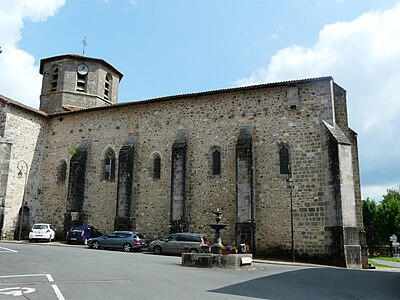 Fountain in front of Notre-Dame-de-la-Nativité
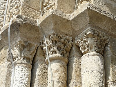 Capitals on the west portal


.JPG)

literature
- G. Le Pochat et al. a .: Feuille Montbron . In: Carte géologique de la France at 1/50 000 . BRGM, 1986.
- Dominique Richard (Ed.): Le Guide Dordogne-Périgord . Éditions Fanlac, Périgueux 1993, ISBN 2-86577-162-8 .
Web links
- Occitan place names in the Dordogne department
- Bussière-Badil on the annuaire-mairie.fr website
- Bussière-Badil on cartesfrance.fr in French
- Population development since 1793 on cassini.ehess.fr
Individual evidence
- ^ Albert Dauzat and Charles Rostaing: Dictionnaire étymologique des Noms de Lieux en France (new edition) . Librairie Guénégaud, 1984.
- ↑ Chantal Tanet and Tristan Hordé: Dictionnaire des Noms de Lieux du Périgord . éditions Fanlac, Périgueux 2000, p. 77 .
- ↑ Bussière-Badil on the Insee website
- ↑ Jacques Hesault: La 40e foire de Potiers de Bussière-Badil présentée . In: Sud Ouest . édition Périgueux, April 20, 2016, p. 18 .