
Busserolles
| Busserolles | ||
|---|---|---|
|
||
| region | Nouvelle-Aquitaine | |
| Department | Dordogne | |
| Arrondissement | Nontron | |
| Canton | Périgord Vert Nontronnais | |
| Community association | Périgord Nontronnais | |
| Coordinates | 45 ° 41 ′ N , 0 ° 39 ′ E | |
| height | 135-305 m | |
| surface | 32.46 km 2 | |
| Residents | 503 (January 1, 2017) | |
| Population density | 15 inhabitants / km 2 | |
| Post Code | 24360 | |
| INSEE code | 24070 | |
| Website | busserollesenperigordvert.a3w.fr | |

Busserolles , Occitan Busseiròla is a French municipality with 503 inhabitants (at January 1, 2017) in the Dordogne in the region Nouvelle-Aquitaine (before 2016 Aquitaine ). It belongs to the Arrondissement of Nontron and the canton of Périgord Vert Nontronnais (until 2015 canton of Bussière-Badil ). The responsible community association is the Communauté de communes du Périgord Nontronnais . The inhabitants are known as Busserollais or Busserollaises .
etymology
The Occitan word bussairòla is a diminutive of bussiera ( French bussière , derived from buis ) and therefore means “an area overgrown by small box trees”. At the end of the 13th century the community is first mentioned as Buxerolla and in the 14th century as Buysserola . On the Carte de Cassini of the 18th century she is depicted as Buxerolles .
geography

Busserolles is the northernmost municipality in the Dordogne department and has a very large area of 32.46 square kilometers.
Busserolles is a border municipality both to the Charente and Haute-Vienne departments . It is surrounded by the following seven parishes:
| Roussines (Charente) | Roussines (Charente) | Maisonnais-sur-Tardoire (Haute-Vienne) |
| Écuras (Charente) |
.svg)
|
Champniers-et-Reilhac |
| Bussière-Badil | Saint-Estèphe | Piégut-Pluviers |
There are countless hamlets, mills, farms and landmarks in the municipal area of Busserolles: Beaulieu , Bellevue , Bois de Puyrocher , Bost Pertus , Chantalouette , Chez Bigot , Chez Gabarian , Chez Garot , Chez Gauchou , Chez Giraudeau , Chez la Lyre , Chez Levraut , Chez Nadaud , Chez Peynaud , Clargourt , Cluzance , Coiraud , Croix de Rougier , Fargeas , Forge-Neuve , L'Étang Grolhier , L'Isle , La Barrière , La Brousse , La Châtaignolle , La Forêt , La Forge de Lavallade , La Garenne , La Maillerie , La Ribière , Lacaud , Lamandeau , Langlade , Le Buisson , Le Chalard , Le Chêne Blanc , Le Cros de l'Ouvrage , Le Dagois , Le Fraisse , Le Graffeuil (area point), Le Graffeuil (hamlet), Le Grand Bost , Le Grand Clos , Le Grand Vilotte , Le Mangot , Le Moulin de Coiraud , Le Moulin de Grolhier , Le Moulin de Ludièras , Le Petit Vilotte , Le Poirier , Le Reclos , Le Roc , Le Verger , Le Villard , Les Chareyroux , Les Fontenelles , Les Joncs , Les Meynieux , Les Potences , Leymeron ie , Ludièras , Malègue , Mirambeau , Moulin de Leymeronie , Nanteuil , Paugnac , Trepeix , Varachaud , Villautrange and Villeneuve .

The topographically lowest point of the municipality is 135 meters above sea level on the Tardoire in the southwest. The highest point at 305 meters above sea level is in the Bois de Puyrocher in the southeast. The maximum difference in altitude is 170 meters. The town center is located at 162 meters above sea level.
Transport links
The community is located away from major traffic axes. Via the D 88 it has a connection to the further north running D 699 from Saint-Mathieu in the Haute-Vienne department to Montbron in the Charente department, and on the other hand to the D 91 from Piégut-Pluviers to Montbron, which runs south. It also has a connection to the neighboring town of Bussière-Badil in the west and Champniers-et-Reilhac in the east via the D 90 . Busserolles is about 10 kilometers from Piégut-Pluviers to the southeast and 15 kilometers from Montbron in the west.
Long-distance hiking trail
The GR 4 long-distance hiking trail runs through the southern part of the municipality from Royan to Limoges and on to Grasse .
Hydrography
.JPG)
Busserolles is located on the Trieux , a left tributary of the Tardoire . In addition, the Ruisseau la Planche and the Ruisseau de l'Étang Grolhier - smaller left tributaries of the Trieux - also cross the municipality . The Ruisseau de l'Étang Grolhier is dammed up into a larger reservoir, the Étang Grolhier , and at the same time forms an important bird sanctuary. The Tardoire is the border river to the Charente department, the Trieux partially delimits the municipality from the neighboring municipalities of Maisonnais-sur-Tardoire and Champniers-et-Reilhac.
The general direction of drainage is to the west or south-west.
geology

The municipality of Busserolles is completely underlain by Variscan basement rocks of the northwestern Massif Central . These include metamorphic rocks such as paragneiss and the metatexites that emerged from them - to be seen in the north and north-west sections. The regional strike direction of the metamorphic rocks is northeast with an angle of incidence of 30 to 60 ° to the northwest.
The deep rocks include the Piégut-Pluviers-Granodiorit , which occupies the entire southern half of the municipality. It usually appears in its coarse-grained normal facies ( γ 3M ), but can also occur in its fine-grained edge and roof facies ( f γ 3M ) and in Malègue in its porphyry facies ( p γ 3M ).
Associated with the granodiorite is its northern apophysis, which is formed as a porphyry micro- granite ( μ γ 3M ). This appendage is only separated from the actual granodiorite massif by a very thin layer of paragneiss not far north of the center of Busserolles. The septum leaves the regional north-east strike and turns to the east - with a very steep dip (by 80 °) to the north.
In the far east near Le Fraisse , the Saint-Mathieu leukogranite with its fine-grain facies is still standing ( Champniers-Reilhac leucogranite - γ 2 ). Two large Roussines leucogranite shear lenses with a north-westerly strike direction are inserted into it . Spatially separated from this, in the valley of the Tardoire on the northwestern edge, the Champniers-Reilhac leuco granite appears again as large, north-north-east to north-east trending shear strains in metatexites near Villautrange and La Forge de Lavallade .
Numerous disturbances pervade the granitoids. Their strike direction is mostly north-northwest, north or north-northeast. Quartz veins or lenses ( Q ) also make use of these directions, flocking arranged like microgranite transitions in leucogranite ( microns .gamma. ) but generally follow the north-northwest direction. At Villautrange , a northwest trending lamprophyre dike cuts through the metamorphic rocks .
The high altitudes north of Le Grand Vilotte and northeast of Chez Giraudeau are covered by Pleistocene colluvium (formation HC ), which masks the underlying basement. Post-glacial Holocene river sands with small quartz and basement rubble were deposited in the floodplains of the Tardoire and Trieux ( Fy-z formation ).
Ecology and environment
.JPG)
Natural park
The municipality of Busserolles has been part of the Périgord-Limousin Regional Nature Park since 1998 .
Protected areas
The valleys of the Tardoire, the Trieux and the Ruisseau de l'Étang Grolhier form an ecological protection zone in the municipal area, especially because of their flora and water quality; in French , these areas are classified under the name Vallées du réseau hydrographique de la Tardoire et du Trieux as a continental ZNIEFF (Zone d'interêt écologique, faunistique et floristique) of type 1.
The Étang Grolhier in the southeast has been designated as an ecotope to be protected (French site naturel ) since 1979 .
history
Evidence of the Gallo-Roman culture is available in Busserolles . The Romanesque local church was built in the 12th century.
Since 1790, the municipality of Busserolles has belonged to the canton of Bussière-Badil, which was initially only called the canton of Bussière and which belonged to the district of Nontron until 1795. In 1795 the districts were dissolved. From 1801 the canton was then incorporated into the Arrondissement of Nontron.
In the course of the territorial reform of 2014, which is regulated by the decree of February 21, 2014, the canton of Bussière-Badil disappeared with the departmental elections in March 2015. Since then, the municipality of Busserolles has been part of the newly created canton of Périgord Vert Nontronnais.
Population development
| Population development in Busserolles | ||||
|---|---|---|---|---|
| year | Residents | Population density |

|
|
| 1962 | 941 | 29 / km² | ||
| 1968 | 818 | 25 / km² | ||
| 1975 | 728 | 22 / km² | ||
| 1982 | 616 | 19 / km² | ||
| 1990 | 569 | 18 / km² | ||
| 1999 | 507 | 16 / km² | ||
| 2004 | 540 | 17 / km² | ||
| 2006 | 548 | 17 / km² | ||
| 2008 | 556 | 17 / km² | ||
| 2009 | 560 | 17 / km² | ||
| 2013 | 528 | 16 / km² | ||
| 2014 | 511 | 16 / km² | ||
| 2015 | 506 | 16 / km² | ||
| 2017 | 503 | 15 / km² | ||
Source: INSEE
The number of inhabitants has generally declined sharply since 1962 (decrease of 46%), with a trend reversal between 1999 and 2009. Busserolles has lost almost half of its inhabitants since 1962.
The population density of Busseolles is very low and is around 15 inhabitants / km².
mayor

The Mayor of Busserolles has been Guy Beauzetier, a farmer from Les Républicains , since June 1995 .
economy
employment
In 2012, the employed population aged 15-64 was 219, which is 40.2% of the total population. The number of unemployed had risen from 18 in 2007 to 30 and thus reached an unemployment rate among the employed of 13.7%.
Companies
As of December 31, 2013, 62 companies were located in the municipality, 30 of them in the trade, transport or services sector, 15 in construction, 10 in the agriculture, forestry or fisheries sector, 4 in industry and 3 in the administration, education, health and Social.
Attractions
- The 12th century Romanesque church of Saint-Martial , modified in the 15th century and Monument Historique since 1958 .
- The Notre-Dame-des-Champs oratory on the left-hand side of the D 90 to Champniers-et-Reilhac was built in 1954. On August 15th it is the destination of an annual pilgrimage.
- The Logis de Chalard at Chez Bigot , the former quarters of the master blacksmith.
Photo gallery
 The Saint-Martial church
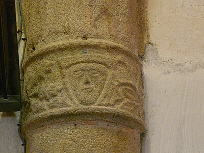 capital
 Corbel
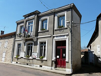 Mairie
 The Logis de Chalard in the Trieux Valley, Chez Bigot
 The Trieux at the north exit of Busserolles
 Mill at Étang Grolhier
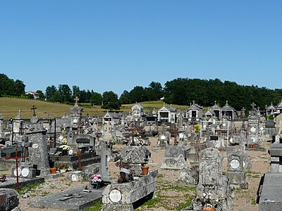 The Busseolles cemetery


.JPG)

.JPG)

.JPG)
literature
- G. Le Pochat et al. a .: Feuille Montbron . In: Carte géologique de la France at 1/50 000 . BRGM, 1986.
Web links
- Website with Occitan place names in the Dordogne department
- Busserolles on the annuaire-mairie.fr website
- Busserolles on cartesfrance.fr in French
- Population development since 1793 on cassini.ehess.fr
Individual evidence
- ↑ Chantal Tanet and Tristan Hordé: Dictionnaire des noms de lieux du Périgord . éditions Fanlac, 2000, ISBN 2-86577-215-2 , p. 76 .
- ↑ Busserolles on the Insee website