Excideuil
| Excideuil | ||
|---|---|---|

|
|
|
| region | Nouvelle-Aquitaine | |
| Department | Dordogne | |
| Arrondissement | Nontron | |
| Canton | Isle-Loue-Auvézère (main town) | |
| Community association | Isle-Loue-Auvézère en Périgord | |
| Coordinates | 45 ° 20 ' N , 1 ° 3' E | |
| height | 140-253 m | |
| surface | 5.02 km 2 | |
| Residents | 1,177 (January 1, 2017) | |
| Population density | 234 inhabitants / km 2 | |
| Post Code | 24160 | |
| INSEE code | 24164 | |
| Website | http://www.excideuil.fr/ | |
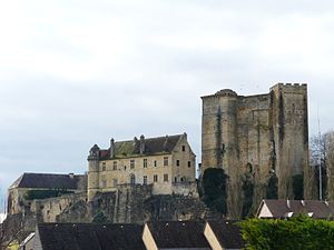
 Excideuil Castle |
||
Excideuil is a French commune with 1,177 inhabitants (at January 1, 2017) in the department of Dordogne in the region Nouvelle-Aquitaine . It belongs administratively to the Arrondissement Nontron and is the capital of the canton Isle-Loue-Auvézére . The residents call themselves Excideuillais (es) .
geography
The municipality is located around 60 kilometers south-southwest of Limoges in the north-east of the Dordogne department and is bordered by Clermont-d'Excideuil to the north, Saint-Médard-d'Excideuil to the east, Saint-Raphaël to the south and Saint-Martial- d'Albarède . Excideuil is passed by the Loue River .
Population development
| 1962 | 1968 | 1975 | 1982 | 1990 | 1999 | 2006 | 2011 |
|---|---|---|---|---|---|---|---|
| 1,978 | 1,660 | 1,663 | 1,535 | 1,414 | 1,318 | 1,318 | 1,184 |
Attractions
- Excideuil Castle , castle complex with parts from the 12th century - Monument historique
- Church Saint-Thomas church from the 15th century - Monument historique
- House from the 18th century - Monument historique
Web links
Commons : Excideuil - collection of images, videos and audio files
Individual evidence
- ↑ Château d'Excideuil in the Base Mérimée of the French Ministry of Culture (French)
- ↑ Église Saint-Thomas in the Base Mérimée of the French Ministry of Culture (French)
- ^ Residence in the Base Mérimée of the French Ministry of Culture (French)
