Soudat
|
Soudat Sodac |
||
|---|---|---|
|
|
||
| region | Nouvelle-Aquitaine | |
| Department | Dordogne | |
| Arrondissement | Nontron | |
| Canton | Périgord Vert Nontronnais | |
| Community association | Périgord Nontronnais | |
| Coordinates | 45 ° 38 ' N , 0 ° 34' E | |
| height | 134-266 m | |
| surface | 8.82 km 2 | |
| Residents | 92 (January 1, 2017) | |
| Population density | 10 inhabitants / km 2 | |
| Post Code | 24360 | |
| INSEE code | 24541 | |
 Soudat |
||
Soudat ( Occitan Sodac ) is a commune with 92 inhabitants (at January 1, 2017) in the Dordogne in the region Nouvelle-Aquitaine . It belongs to the Arrondissement of Nontron and the canton of Périgord Vert Nontronnais (until 2014: Bussière-Badil ). The responsible community association is the Communauté de communes du Périgord Nontronnais . The inhabitants are called Soudatois or Soudatoises .
geography
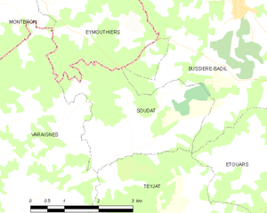
Soudat, located in the Périgord Vert , eight kilometers southeast of Montbron ( Charente ) and four kilometers (as the crow flies) southwest of Bussière-Badil , is a border municipality to the Charente department.
Soudat is surrounded by the following five neighboring communities:
| Eymouthiers (Charente) | Bussière-Badil | |
| Varaignes |

|
Bussière-Badil |
| Teyjat | Étouars (point of contact) |
The municipality of Soudat includes the following hamlets, farms and landmarks: Bost du Mat , Chez Tendeau , La Basse Côte , La Chapelotte , La Grelière , La Guillaumie , Langlardie , Les Bories , Les Brousses , Les Chaumes , Les Forêts , Les Justices , Pellegrenier , Soudat and Vermont .
The area around Pellegrenier is almost an enclave between the municipalities of Bussière-Badil and Eymouthiers.
The topographically lowest point of the municipality is at 134 meters above sea level on the Crochet in the extreme southwest, the highest point at 266 meters above sea level at Langlardie on the eastern border. The maximum height difference is 132 meters. The center is at 190 meters.
Transport links
On the northern edge of the municipality, the D 6 (which then merges into the D 91 in the Dordogne) runs from Montbron to Piégut-Pluviers . The center of Soudat, which is further south, can be reached from the D 6 via a municipal road (junction at the hamlet of Les Justices ); this then continues to Varaignes . From Les Justices , the D 90 crosses the northwestern municipality in the direction of Varaignes.
Hydrography
The southern border of the municipality is formed by the Crochet , a right tributary of the Bandiat . The crochet drains to the southwest; at the hamlet of La Grelière it takes on a right branch, the Ruisseau le Pontet . The upper reaches of the Crochets before the confluence with the Pontet is known as the Ruisseau de l'Étang d'Assat . The center of Soudat has a spring from which a small right branch of the Pontets rises. The Pontet itself has its origin on the northern border north of Pellegrenier and drains in a south-south-west direction. From the east-northeast direction, it takes in several smaller side valleys. The western border of the municipality follows a right-hand, south-facing dry valley that flows into the Crochet at La Basse Côte .
geology
The Ruisseau de l'Étang d'Assat and the Ruisseau le Pontet have cut into the Variscan basement of the north-western Massif Central (see in this context Saint-Mathieu-Dom ), which is represented here by migmatitic paragneiss (Metatexites - Mζ 1-2 ) becomes.
Downstream transgredieren south of the town center and north-west of Chez Tendeau Liassedimente ( sandstones , arkose and Dolomite the Hettangiums (Formation L1-4 ), brecciation and sandstones Pliensbachiums overlaid by gray-blue shales and dolomite of Toarciums - Formation l5-9 ).
Above the Lias follow in the west of the municipal area recrystallized limestone of the Doggers (Formation jC ). In the hamlet of Les Bories, these are overlaid by gray oolite limestone (with brown ooids ) of the Middle Bathonium (formation j1b ).
The ridge on the northern edge of the municipality consists of the tertiary alluvium ( sand , gravel , gravel and clays of the HF formation ) of a former river system. The back at Langlardie forms a side branch of this. The slopes further downwards are built up from colluvium of the HC formation , which partly covers the basement and partly the sediments; these are rearrangements of the tertiary alluvium. The valleys of Crochet and Pontet, but also the dry valley, are filled with Holocene alluvium of the Fy-z formation .
Village north of Soudat was in the 19th century in the formation HC nor iron ore won, consisting wiederaufgearbeitem (probably eozänem ) Sidérolithique came.
ecology

Natural park
The municipality of Soudat has been an integral part of the Périgord-Limousin Regional Nature Park since 1998 .
Protected area
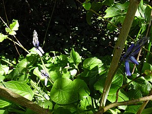
The entire valley of the Ruisseau de l'Étang d'Assat is under nature protection . This area is designated as ZNIEFF (French zone naturelle d'intérêt écologique, faunistique et floristique ) of type 1 under the name Vallées du réseau hydrographique du Bandiat . The flora consists of more than 100 plant species with large orchards ( Agrimonia procera ) and Atlantic hare bells ( Hyacinthoides non-scripta ) as indicator plants.
history
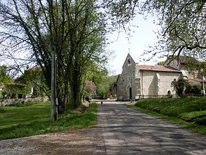
The oldest building in Soudat is the Romanesque church, whose former style can no longer be recognized due to later renovations.
Population development
| Population development in Soudat | ||||
|---|---|---|---|---|
| year | Residents |

|
||
| 1962 | 150 | |||
| 1968 | 121 | |||
| 1975 | 98 | |||
| 1982 | 99 | |||
| 1990 | 78 | |||
| 1999 | 72 | |||
| 2006 | 82 | |||
| 2007 | 83 | |||
| 2011 | 85 | |||
| 2016 | 93 | |||
| 2017 | 92 | |||
Source: INSEE
The population of Soudat is generally declining, only since 1999 has a slight trend reversal been discernible.
With an area of 8.82 square kilometers, the population density is now 10 inhabitants / km². Soudat was the smallest municipality in terms of population and the second smallest municipality in terms of area in the canton of Bussière-Badil. In the current canton of Périgord Vert Nontronnais, it is the second smallest municipality in terms of population and the third smallest in terms of area. Soudat also now has the second lowest population density.
mayor
The mayor of Soudat has been the independent farmer Jean-Claude Rathier since March 2001.
Attractions
- Saint-Julien-de-Brioude church
The former Saint-Romain church has now disappeared without a trace.
Individual evidence
literature
- G. Le Pochat et al .: Carte géologique de la France à 1/50 000. Feuille Montbron . BRGM, 1986.


