
Saint-Saud-Lacoussière
|
Saint-Saud-Lacoussière Sensaut e la Cossiera |
||
|---|---|---|
|
||
| region | Nouvelle-Aquitaine | |
| Department | Dordogne | |
| Arrondissement | Nontron | |
| Canton | Périgord Vert Nontronnais | |
| Community association | Périgord Nontronnais | |
| Coordinates | 45 ° 33 ' N , 0 ° 49' E | |
| height | 189-370 m | |
| surface | 58.04 km 2 | |
| Residents | 832 (January 1, 2017) | |
| Population density | 14 inhabitants / km 2 | |
| Post Code | 24470 | |
| INSEE code | 24498 | |
 Saint-Saud-Lacoussière, view from the southwest |
||

Saint-Saud-Lacoussière ( Occitan Sensaut e la Cossiera ) is a commune of 832 inhabitants (at January 1, 2017) of the North department Dordogne in the region Nouvelle-Aquitaine . It belongs to the Arrondissement of Nontron and the canton of Périgord Vert Nontronnais (until 2014: Saint-Pardoux-la-Rivière ). The responsible community association is the Communauté de communes du Périgord Nontronnais . The inhabitants are known as Saint-Saudois or Saint-Saudoises .
etymology
The origin of the Occitan sensaut is not entirely clear. The second word syllable saut means a wooded slope or a ravine (literally jump ). La cossiera is a variant of la corsiera meaning gutter or ditch .
geography
Saint-Saud-Lacoussière is halfway between Nontron and La Coquille . The distance to Nontron in the west is twelve kilometers and to La Coquille in the east it is also twelve kilometers (as the crow flies).
The community is surrounded by the following eight neighboring communities:
| Abjat-sur-Bandiat | Pensol (Haute-Vienne department) | Mialet |
| Saint-Pardoux-la-Rivière , Champs-Romain |
.svg)
|
Mialet |
| Milhac-de-Nontron | Saint-Martin-de-Fressengeas | Saint-Jory-de-Chalais |
Saint-Saud-Lacoussière is a commune on the border with the Haute-Vienne department . In terms of area, it is the largest municipality in the canton of Périgord Vert Nontronnais with 58.04 km². In addition to the town center, their area includes numerous hamlets, farmsteads, castles, mills, forges, brickworks and landmarks:
Aux Juges , Beynac , Bœuf Mort , Bois de la Chapelle , Bois de Mazaudet , Bois du Pimpidour , Bois de Tendeix , Bonnefond , Bourbon , Bourneix , Chapellas , Châtaignier , Château de Beynac , Chez Farjouty , Claud de la Veyrière , Contussier , Côte Chaude , Étang de Bonnefond , Étang de la Garenne , Étang de Pabot , Fontaine de la Goutte , Forge de la Maque , Grand Étang , Grandcoing , Jalazier , L'Aubade , La Beauzetie , La Besse , La Bucherie , La Chapelle Verlaine , La Fontaine de Loriot , La Forêt , La Forêt de Beynac , La Garde , La Gourgousse , La Jurie , La Maque , La Petite Garde , La Petite Sagne , La Peyrière , La Pinalie de Grandcoing , La Pinalie de Montagnac , La Porcherie , La Rebière , La Rouderie , La Sagne , La Tuilerie de la Veyrière , La Valade , La Veyrière , La Villotte , Lacoussière , Lage , Larret , Le Breuil , Le Claud du Four , Le Grand Peytour , Le Grand Roc , Le Monteix , Le Moulin de Lacoussière , Le Moulin de Maziéras , Le Pic , Le Pimpidour , Le Puy , Le Ro udat , Le Tendeix , Le Vieux Moulin , Les Bordes , Les Carrières , Les Clèdes , Les Couderchoux , Les Farges , Les Gargalines , Les Grafouillades , Les Marottes , Les Paleyres , Les Petites Bordes , Les Peychères , Les Places , Les Quatre Routes , Les Rivalles , Les Tuileries de Vaure , Maberout , Maisonneuve , Manaud , Mazaubrun , Mazaudet , Maziéras , Montagnac , Moulin de Grandcoing , Moulin du Pont , Mouton , Nicolas , Petit Peytour , Peyfreix , Peyrouse , Pont des Brasdoux , Puydoyeux , Saut du Chalard , Soumagnac , Trou de Philippou , Vachaumard , Vacher , Vaure , Veyrinas and Vieille Abbaye .
The topographically lowest point of the municipality is 189 meters above sea level on the Dronne in the west, the highest point with 370 meters in the extreme northeast at le Roudat . The absolute height difference is 181 meters. The town center is at 300 meters above sea level.
Transport links

Coming from La Coquille, the D 79 crosses the town center and continues west towards Nontron . At the northern edge of the municipality runs the D 6a (Haute-Vienne), which is referred to as D 85 in the Dordogne; it comes from the northeast of Dournazac and then moves on to Nontron. The southern part of the municipality (left side of the Dronne valley) runs through the D 82 from Mialet to Villars in a south-westerly direction . A north-south municipal road also crosses in the town center; it provides connections to the D 6a in the north and the D 82 in the south; it also enables a connection to Thiviers .
Long-distance hiking trail
The long-distance hiking trail GR 361 crosses the community roughly in the middle in a north-south direction.
Hydrography
The municipality is traversed by the Dronne roughly in the middle . The meandering river has cut up to 100 meters deep into the basement and created a gorge-like valley. The Dronne initially flows south and at the same time forms the northeast border to Mialet. After changing course to the south-west, it crosses the municipality coming from the east and passes the center of Saint-Saud-Lacoussière in the south. It maintains the southwest direction until it leaves the municipality west of Larret . On its last two kilometers it is the border river to Champs-Romain. Notable tributaries are the right-hand Ruisseau de la Bucherie and the also right-hand Ruisseau la Malencourie . The course of the latter stream extends the western border to Champs-Romain to the north. The southeast boundary of the municipality is defined by the Queue d'Ane , a right tributary of the Côle, which meanders to the south-southwest .
geology

Saint-Saud-Lacoussière lies entirely on the metamorphic basement of the north-western Massif Central . The eastern part of the municipality is traversed by the mica slate band ( ξ 1 ) of the parautochthonous mica slate unit in a north-south direction. The strike direction of the mica schist varies between northwest and north-northeast, but on average points to north-northwest. The relatively flat angle of incidence is generally 20 to 40 ° to the east-north-east, but can also take on very steep values in more closely folded mica slate stretches (in hinges). However, very strong scattering of the foliations can also be observed locally . The folds are generally West Vergent. The linear lines encountered fall flat to the south-east (scatter range east-north-east to south-south-east).
Associated with mica schists is the Saint-Mathieu leukogranite , which occurs in the western part of the municipality in its Saint-Saud facies ( γ 2M or γ 2 b-m ). In the outgoing Upper Carboniferous , the leucogranite penetrated into the contact area of the mica schist with the paragneiss ( ζ 1-2 ) that it had run over (the paragneiss are further west in the municipality of Champs-Romain). That it is an anatectic melting product of mica slate can be seen from the mica slate islands or trains carried in it (a fine example of this can be found at the school of Saint-Saud-Lacoussière). The bulk of the leukogranite ends south of the Dronne, but continues further south in an apophysis around Veyrinas and Bonnefond .
Above the mica schists - the structurally deepest unit in the Massif Central - Augengneise and Leptynite follow the lower gneiss cover of the Limousin . The augengneisses ( OC ζλ 3 b ) are at the extreme edge at Northeast Les Grafouillades just along a north-trending fault open; they also occur on the south-eastern border south of vielle Abbaye . Several persistent leptynite trains ( λ ) are also found in the mica schists near Grandcoing .
The leucogranite is interspersed with corridors of lamprophyren ( ν ), which strike mainly north to north-northeast. Also microgranite - ( microns .gamma. ) and quartz veins ( Q ) are found in leucogranite that are usually very similar oriented underline or Northwest or Northeast.
Faults in the basement usually follow typical Variscan strike directions - north-northwest, north, north-northeast and northeast,
Extensive altitudes in the municipal area are often veiled by relatively thin, colluvial alterites of the Pleistocene (Formation AC ) - worm-age sands originating from gneisses and granites as well as quartz pebbles arising from quartz lenses and veins. The valleys of the Dronne and the Queue d'Ane are filled with up to 2 meters thick alluvium from the Würm Glaciation and the Holocene (Formation K ). The debris carried along can have a diameter of 30 to 50 centimeters.
ecology
The municipality of Saint-Saud-Lacoussière is an integral part of the Périgord-Limousin Regional Natural Park .
history
In 1163 the Cistercians founded an abbey in Peyrouse , which was one of the four Cistercian abbeys in the Périgord . It is not clear whether the hamlet of Vieille Abbaye is related to this. The Romanesque local church of Saint-Saud-Lacoussière was also built in the 12th century . It contains wooden statues from the former Cistercian abbey. The Lacoussière castle , which was destroyed again during the Hundred Years War , was built around the same time . The Château de Beynac was built in the 19th century on a much older foundation.
Population development
| Population development in Saint-Saud-Lacoussière | ||||
|---|---|---|---|---|
| year | Residents |

|
||
| 1962 | 1468 | |||
| 1968 | 1284 | |||
| 1975 | 1148 | |||
| 1982 | 1045 | |||
| 1990 | 951 | |||
| 1999 | 868 | |||
| 2005 | 861 | |||
| 2006 | 859 | |||
| 2007 | 856 | |||
| 2010 | 868 | |||
| 2015 | 844 | |||
| 2016 | 839 | |||
| 2017 | 832 | |||
Source: INSEE
The population development in Saint-Saud-Lacoussière has generally declined since 1962 (population loss of 43 percent), but had recovered somewhat briefly between 2007 and 2010.
With an area of 58.04 square kilometers, the population density is 14 inhabitants / km².
mayor
Mayor of Saint-Saud-Lacoussière was since March 2001 the non-party farmer Sylvie Seegers. The office has been held by Pierre Duval since March 2014.
Attractions
- Romanesque church Saint-Étienne of Saint-Saud-Lacoussière from the 12th century, made of leuco granite
- Ruins of the Château de Lacoussière
- Ruins of the Cistercian Abbey of Peyrouse
- Rapids of the Saut du Chalard on the Dronne
- 12 hectare Grand Étang swimming lake north of the town center
Photo gallery
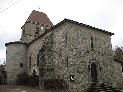 Saint-Etienne Church of Saint-Saud-Lacoussière
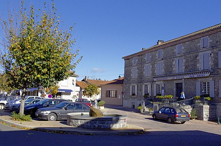 Central place
 thimble
 Town entrance
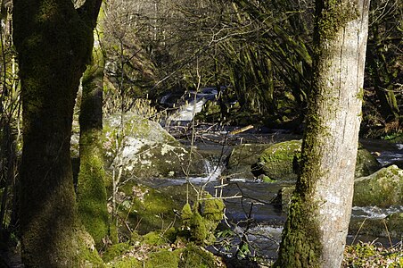 Saut du Chalard in winter


Individual evidence
literature
- B. Briand et al. a .: Feuille Châlus . In: Carte géologique de la France à 1/50000 . BRGM.
- P.-L. Guillot et al. a .: Feuille Thiviers . In: Carte géologique de la France à 1/50000 . BRGM, ISBN 2-7159-1810-0 .