
Monsec
| Monsec | ||
|---|---|---|
|
||
| local community | Mareuil en Périgord | |
| region | Nouvelle-Aquitaine | |
| Department | Dordogne | |
| Arrondissement | Nontron | |
| Coordinates | 45 ° 25 ' N , 0 ° 32' E | |
| Post Code | 24450 | |
| Former INSEE code | 24283 | |
| Incorporation | January 1, 2017 | |
| status | Commune déléguée | |
.JPG) Notre-Dame-de-la-Nativité church at night |
||

Monsec ( Occitan Mont Sec ) is a town and commune Déléguée in the French commune of Mareuil en Périgord with 195 inhabitants (as of January 1 2017) in the northwest of the department Dordogne , Region Nouvelle-Aquitaine . The territory of the Commune déléguée is an integral part of the Périgord-Limousin Regional Natural Park .
etymology
The place name Monsec, in Occitan Mont Sec, is derived from French. Mont (mountain, hill) and sec (dry, arid). This is likely to refer to the rather arid altitudes of the Upper Cretaceous.
geography

Monsec is 11 kilometers northwest of Brantôme and 7 kilometers southeast of Mareuil (as the crow flies). The municipality of Monsec was surrounded by the following neighboring municipalities:
- Champeaux-et-la-Chapelle-Pommier in the north
- Saint-Félix-de-Bourdeilles to the east
- Léguillac-de-Cercles in the south
- Vieux-Mareuil to the west
In addition to the town center, the Commune déléguée consists of the following hamlets, farmsteads and a former forge:
Badaillac , Beauséjour , Chassenat , Chez Briaudet , La Belle , La Forge de Mondevit , La Prade , Les Ages , Les Potences , Petit Brégnac , Petit Marafy , Pontarnaud , Puychauvaux , Puypeyroux , Puyrial and Trépacie .
The area of the Commune déléguée is drained by the Belle , which rises in the northeast west of the hamlet of Pontarnaud . It initially flows to the southwest, but turns in the west-northwest direction when you reach the hamlet of La Belle . A north-north-west facing dry valley marks part of the western border to Vieux-Mareuil, it flows into the Belle as a left side valley at Badaillac .
The topographically lowest point in the area of the Commune déléguée of Monsec with 131 meters is in the hamlet of Badaillac in the west on the Belle, which leaves the Commune déléguée here. The highest point at 237 meters is located in the extreme northeast corner. The absolute difference in height was thus 106 meters.
geology
The Commune déléguée Monsec is completely underlain by sediments from the northeast Aquitaine Basin . The deepest exposed layer is the Ligérien ( Unterturon ) - bulbous, flat chalk limestone . It lines the left side of the valley of the Belle near Badaillac . This is followed by the rudist limestone of the Lower and Upper Angoumia . The Upper Angoumien is open in the town center. The upper Angoumien is followed by the hard fossil limestone of the Coniacium , to be seen in the south of the Commune déléguée and north of the town center near Puyrial . The gray limestones of the Lower Santonium , containing glauconite, lie on top of the coniacium (near Les Potences on the southern border of the Commune déléguée). The oysters Schill -containing marl of the Upper Santoniums are north of Puyrial and Puychauvaux on. The generally flat layer sequence of the Upper Cretaceous ends with the gray-white chalk limestone of the Lower Campanium near La Prade . An alluvial gravel tongue from the Eocene or Lower Oligocene transgressed onto the Upper Cretaceous . It was poured to the southwest and follows the municipal boundary from Pontarnaud to Les Potences . It is conglomerated in places and contains quartz and silicified arkose gels . Large parts of the northern area of the Commune déléguée are covered by the encircled Pleistocene colluvium , which emerged from the sands of the Upper Canton. Remains of coarse clastic colluvium and lower Pleistocene alluvium are also present. The numerous karst caves in the Upper Cretaceous are also worth mentioning .
The Mareuil Fault splits in the area of the Commune déléguée of Monsec into two branches that follow an east-south-east and a south-east direction. This fault system is the eastern extension of the Mareuil anticline . It caused the central and southern floe to rise in a staircase-like manner with displacements of around 50 and 30 meters respectively. In addition, the layer bond was disturbed, for example at Beauséjour it shows a dip of 15 ° to the northeast or west of Puyrial a dip of 6 ° to the southeast.
At La Forge de Mondevit , gravel and sand were once mined in the alluvial gravel tongue . Activated pitches provided the raw material for a brickworks that had now fallen into disrepair .
history
The oldest preserved building in Monsec is the Renaissance church Notre-Dame de la Nativité, built in 1508 . At that time Monsec was a stopover on the Camino de Santiago .
The municipality of Monsec became with effect from January 1, 2017 with the municipalities of Champeaux-et-la-Chapelle-Pommier , Les Graulges , Léguillac-de-Cercles , Mareuil , Beaussac , Puyrenier , Saint-Sulpice-de-Mareuil and Vieux-Mareuil merged to form the Commune nouvelle Mareuil en Périgord and has since had the status of a Commune déléguée there. It belonged to the canton of Brantôme (until 2015 to the canton of Mareuil ).
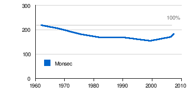
Population development of the former municipality
| Population development in Monsec | ||||
|---|---|---|---|---|
| year | Residents |
|
||
| 1962 | 218 | |||
| 1968 | 203 | |||
| 1975 | 181 | |||
| 1982 | 168 | |||
| 1990 | 167 | |||
| 1999 | 153 | |||
| 2008 | 181 | |||
| 2016 | 199 | |||
Source: INSEE
The population in the municipality of Monsec declined until 1999, but has seen a slight upward trend since then.
Infrastructure
Transport links
The center of Monsec is in the immediate vicinity of the main artery D 939 from Angoulême to Périgueux . The D 84 from Nontron to Vertrieblac runs along the entire south-eastern border of the municipality. A municipal road coming from Champeaux-et-la-Chapelle-Pommier crosses the town center and then continues in a south-westerly direction to Léguillac-de-Cercles.
Attractions

Sights in the Monsec municipality are:
- Church Notre-Dame de la Nativité from the early 16th century Renaissance input, since 1925 historique Monument
- Château des Ages
Individual evidence
swell
- J.-P. Floc'h ao: Feuille Nontron . In: Carte géologique de la France at 1/50 000 . BRGM, Orléans.