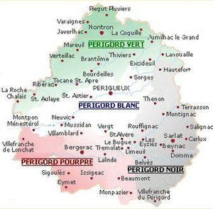
Périgord vert
The Périgord vert , together with the blanc Périgord , the noir Périgord and Périgord pourpre one of the four tourist subdivisions of the Perigord .
etymology
The French adjective vert has the meaning green, greenish in German . The color refers to the extensive forests , arable and pasture areas characteristic of this region .
geography

The Périgord vert - a more recent tourist term - occupies the north-west and north of the Dordogne department . Its limits are not precisely defined. In particular, its extension to the south and south-west, where it spills over to parts of the Périgord blanc, the Ribéracois and the Double , is handled differently by authors. However, it always contains the north and northeast of the department, which corresponds to the landscape of the Nontronnais .
The following major municipalities form part of the Périgord vert:
- Brantôme
- Bourdeilles
- Champagnac-de-Belair
- Excideuil
- Javerlhac-et-la-Chapelle-Saint-Robert
- Jumilhac-le-Grand
- La Roche-Chalais
- Lanouaille
- Mareuil-sur-Belle
- Montagrier
- Ribérac
- Saint-Aulaye
- Saint-Jean-de-Côle
- Saint Privat en Périgord
- Thiviers
- Distribution
- Villars .
The Pays Périgord vert municipal association also includes Sorges .
The landscape of the Périgord vert has a very rural character. It is surrounded by the river plain of the Isle in the south, the Charente-Maritime department in the south-west, the Charente department in the west and north-west and the Haute-Vienne department in the north and north-east. The main rivers are the Dronne and the Bandiat . The urban centers are the sub-prefecture of Nontron (3,444 inhabitants in 2008), Ribérac (4,125 inhabitants, around 5,700 in the metropolitan area) and Thiviers (3,147 inhabitants).
With 3,106 square kilometers - with a maximum extension of 110 kilometers in east-northeast-west-southwest direction and 50 kilometers in north-south direction - the Périgord vert is one of the largest natural regions in Nouvelle-Aquitaine . Its population is 84,687 inhabitants (INSEE 2013), which corresponds to a population density of 27.25 inhabitants per square kilometer.
administration
The Périgord vert administratively belongs to two arrondissements , the Arrondissement Nontron and the Arrondissement Périgueux . It contains a total of six cantons and six associations of communes ( Communauté de communes ).
The cantons are:
- Isle-Loue-Auvézère canton
- Canton of Thiviers
- Canton of Périgord Vert Nontronnais
- Canton of Brantôme
- Canton of Ribérac
- Canton of Montpon-Ménestérol .
The following municipal associations are responsible for the Périgord vert:
- Community de communes Isle-Loue-Auvézère en Périgord
- Communauté de communes Périgord-Limousin
- Communauté de communes du Périgord Nontronnais
- Communauté de communes Dronne et Belle
- Communauté de communes du Pays Ribéracois
- Communauté de communes du Pays de Saint-Aulaye .
ecology
A total of 52 municipalities in the north and northeast of the Périgord vert are integrated into the Périgord-Limousin Regional Nature Park . Around 36 percent of the total area is covered by forests.
See also
- Dordogne department
- Arrondissement of Nontron
- Arrondissement of Périgueux
- Nontronnais
- Périgord
- Périgord blanc
- Périgord central
literature
- Frédéric Zégierman: Le Guide des pays de France, Sud . Fayard, 1999.
Individual evidence
- ↑ Patrick Ranoux: Atlas de la Dordogne-Périgord . Speed impression, 1996, ISBN 978-2-9501476-1-5 , pp. 15 .

