Double (landscape)
The Double is a heavily forested French landscape in the west of the Dordogne department and in the extreme northeast of the Gironde department ( Nouvelle-Aquitaine region ).
etymology

The designation Double, French La Double or Forêt de la Double , Occitan Dobla , probably goes back to the Gallic root Dubus or Dubis and also Dubulā with the meaning black . Related to this are the Old Irish Dub , the Old Welsh Dub- , the Welsh and Breton Du and the Cornish Duw , all with the same meaning. Germanized forms are Toppwald or Tobbwald . Obviously the dark forests gave the landscape its name and not the other way around.
geography
The double is surrounded by the following landscapes:
- the Ribéracois in the north
- the Périgord central in the east
- the Landais in the south
- the Libournais and the Blayais in the southwest
- the Double de Saintonge in the west
- the Montmorélien in the northwest.
The Double extends over an area of almost 500 square kilometers over the central west of the Dordogne department and the northeast of the Gironde department (with the municipalities of Saint-Christophe-de-Double and Saint-Antoine-sur-l'Isle ). The maximum length in the east-west direction is 40 kilometers with a width of 20 kilometers. Their heights vary between 25 meters on the Isle and 159 meters in the southeast, the average height is about 100 meters. Major towns in the area are La Roche-Chalais , Montpon-Ménestérol , Mussidan and Saint-Aulaye . Three municipalities have the addition Double in their place names: Saint-André-de-Double , Saint-Christophe-de-Double and Saint-Michel-de-Double .
Up until the 20th century, a distinction was made between the Double du Périgord in the east of the Dronne and the Double de Saintonge, which is geomorphologically identical, in the west of the river. The term double is now mainly used only for the eastern part of the Périgord , although originally the entire wooded massif was meant here. The term Double du Périgord is still in use.
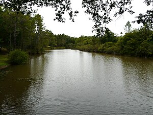
In terms of landscape, the Double represents a broad, wooded plateau in which smaller hills and valleys alternate with one another. Due to the impermeability of their clay, sand and gravel soils, there are countless small ponds and lakes of natural and artificial origin. There are over 500 such water points - the largest of them with 33 hectares is the Grand étang of La Jemaye .
Note: Occasionally, the Double is extended further east beyond the Beauronne into the northern surroundings of Saint-Astier . This means an increase in the maximum heights to 233 meters and a reaching down of the layers to the base of the campanium near Saint-Astier.
administration
The double forms part of the Arrondissement Périgueux in the Dordogne department and the Arrondissement Libourne in the Gironde department. The cantons in the Dordogne department are the cantons of Montpon-Ménestérol , Ribérac and Vallée de l'Isle, as well as the canton of Le Nord-Libournais in the Gironde department . Since 2014, the Communauté de communes Isle Double Landais has been responsible as a community association in the Dordogne department, and the communauté d'agglomération du Libournais in the Gironde department .
Hydrography
The forests of the Double are framed by four rivers - the west-meandering Isle in the south, the Dronne , which meanders to the south-south- west, the Rizonne , which drains to west-north-west, and the Beauronne, which also flows south-south-west, in the east. Right-hand tributaries of the Isle, which borders the Double in the south, are:
- the Beauronne - forms the eastern border
- the grolet
- the Farganaud (also: Fayoulet)
- the Duche with its tributary Petite Duche
- the Courbarieu .
The Dronne cuts through the Double and limits the Double du Périgord to the west. Their left-hand tributaries are:
- the Rizonne (also: Rissonne) - forms the northern border
- the Chalaure .
geology
Geologically, the Double belongs to the Aquitaine Basin and is composed almost entirely of flat layers of the continental Tertiary of fluvial origin. The sequence of layers includes the Upper Cretaceous , Eocene , Oligocene and Pliocene . In addition to the Lower to Middle Eocene Sidérolithique, the Sables du Périgord of the Upper and Lower Oligocene predominate in the Double . The continental Tertiary lies unconformably on Upper Cretaceous ( Obercampan ).
The upper campan appears on the northern edge of the Double along the Rizonne and at the southern exit of the Beauronne Valley, the rest of the Double is covered by Tertiary. The Tertiary, for its part, shows great differences in thickness - from a few meters on the northern edge to over 200 meters in the south. At high altitudes, Pliocene also appears over the Eocene and Oligocene. The valleys are filled by various terraces of the Quaternary - formed during the last three ice ages .
The just opened upper campan consists of soft yellowish chalk limestone . Then a regression set in and the Upper Chalk Sea withdrew completely from the Aquitaine Basin. From the Lower Eocene ( Ypresian ) detritic masses with kaolinite- rich tones were deposited in an inland delta from the Massif Central . In the Middle Eocene, very coarse-grained detritus with gravel and large boulders was poured in - possibly in connection with the Pyrenees orogenesis . The Upper Eocene was characterized by a very reduced sedimentation with simultaneous intensive weathering. The Oligocene brought again quite coarse detritus and smectite clays. Sedimentation stopped during the Miocene . In the following Pliocene there was a last entry with coarse detritus, which sometimes severely affected the underlying topography. From the early Quaternary onwards, the current courses of the river were created, initiated by layers of gravel with sometimes very large boulders. Under periglacial conditions, the water network of the Isle and Dronne was structured in a sequence of terraces. In the Holocene , however, the kinetic energy decreased, so that the rivers could no longer remove alluvium and clayey and even boggy sediments could settle on the last terraces of the worm .
The layers of the Upper Cretaceous, hidden in the deeper subsurface, form a hollow structure - the Saintes Syncline below La Roche-Chalais. The Variscan crystalline basement is located below the Double at a depth of 2000 meters. For example, in the borehole near Saint-Géry in Landais, carbonic shale was encountered at 2052 meters.
ecology
The valley lowlands in the Double are made up of alluvial forests made of black alder ( Alnus glutinosa ), common ash ( Fraxinus excelsior ), English oak ( Quercus robur ) and Pyrenean oak ( Quercus pyrenaica ). Furthermore, there are wet heaths of Dorset heather ( Erica ciliaris ) and bell heather ( Erica tetralix ) as well as raised bogs . These lowlands take up more than 20 percent of the total area and are regarded under Natura 2000 as enormously important areas of land for the conservation of threatened European animal species.
The European pond turtle ( Emis orbicularis ), the jackdaw crab ( Austropotamobius pallipes ), the otter ( Lutra lutra ), the European mink ( Mustela lutreola ), the bullhead ( Cottus gobio ) and even the brown lamprey ( Lampetra planeri ) are found here.
history
The Double was once part of the historic province of the Périgord and was known as Sylva Edobola from the 7th century . At that time it was discredited because it represented a retreat for wild animals and crooks. In 768, Waifar , Duke of Aquitaine, was murdered near Eygurande .
In the Middle Ages , the term double encompassed a much larger area and included the Double de Saintonge (including Brossac , Barbezieux , Baignes , Montguyon , Montlieu , Montendre , Reignac and Laruscade ), the Landais south of the Isle to Vergt in the south-east and areas west of Périgueux (with the forests of La Chapelle-Gonaguet , Beaulieu and Chancelade ).
The Bastide Saint-Barthélemy-de-Bellegarde was founded by the English in the Double in 1316 .
From the 18th century, the timber in the Double was intensively exploited for the nearby shipyards in Bordeaux and La Rochelle . What remained was a sad heather strewn with ponds and ponds. The landscape had become hostile and hostile, and its inhabitants ( French doubleauds ) suffered from moisture, malnutrition and malaria . This has been vividly described in the novel L'ennemi de la mort by Eugène Le Roy .
In the Second Empire , the Double and the neighboring Landais were drained and reforested, mainly with maritime pines .
Because of its dense forests, the Double has always been a refuge for the persecuted. Even during the Second World War, the double was avoided by the German Wehrmacht, as countless resistance fighters (French maquisards ) had holed up in it.
See also
literature
- Florence Broussaud-Le Strat: La Double Un pays en Périgord . Éditions Fanlac, 2006, ISBN 2-86577-252-7 .
- J. Dubreuilh: Montpon-Ménestérol 1735 Etang et Forêt de la Double . In: Carte géologique de la France at 1/50 000 . BRGM, 1984.
Individual evidence
- ^ Bénédicte and Jean-Jacques Fénié: Dictionnaire des pays et provinces de France . Editions Sud Ouest, 2000.
- ^ Xavier Delamarre: Dictionnaire de la langue gauloise . Éditions Errance, 2003, p. 152 .
- ↑ Patrick Ranoux: Atlas de la Dordogne - Périgord . 1996.
- ↑ Chantal Tane and Christian Horde: Dictionnaire des noms de lieux du Périgord . Editions Fanlac, 2000.


