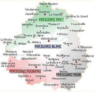
Périgord blanc
The Périgord blanc is, together with the Périgord noir , the Périgord pourpre and the Périgord vert, one of the four tourist subdivisions of the Périgord .
etymology
The French adjective blanc means white, white in German . The color refers to the pending white Upper Chalk stone, with which countless buildings in this landscape were erected.
geography

Geographically, the Périgord blanc extends to the landscapes of the Périgord central , the Ribéracois , the Double and parts of the Landais .
Formerly the limestone plateau of Ribéracois and were Verteillacois called Périgord blanc. Today, however, both landscapes form part of the Périgord vert .
At the beginning of the 21st century, the Périgord blanc essentially corresponds to the landscape on both sides of the Isle , which crosses the northeast and the central west of the Dordogne department . It begins roughly at the confluence of the Loue in the Isle of Coulaures and ends when it reaches the western border to the Gironde department at Le Pizou .
The tourist Périgord blanc is often equated with the landscape of the Périgord central, although strictly speaking this is not correct as the two territories are not congruent. The Périgord central also includes the Pays d'Hautefort , so it extends much further to the east. But it ends in the west at the height of Saint-Astier and does not touch either the Double or the Landais.
In addition to Périgueux , the capital of the Dordogne department, the following important municipalities are located in Périgord blanc:
- Cubjac
- Montpon-Ménestérol
- Mussidan
- Neuvic
- Saint-Astier
- Savignac-les-Églises
- Worry
- Vergt
See also
- Dordogne department
- Périgord
- Arrondissement of Périgueux
- Périgord central
- Double (landscape)
- Landais (landscape)
Individual evidence
- ↑ Patrick Ranoux: Atlas de la Dordogne-Périgord . Speed impression, 1996, ISBN 978-2-9501476-1-5 , pp. 15 .
