Saugeen River
| Saugeen River | ||
|
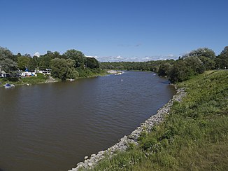
Saugeen River in Southampton |
||
| Data | ||
| location | Ontario (Canada) | |
| River system | Saint Lawrence River | |
| Drain over | St. Clair River → Detroit River → Niagara River → Saint Lawrence River → Atlantic Ocean | |
| source | north of Dundalk 44 ° 15 ′ 2 ″ N , 80 ° 21 ′ 7 ″ W |
|
| muzzle | near Southampton in the Huron Sea Coordinates: 44 ° 30 ′ 3 " N , 81 ° 22 ′ 23" W 44 ° 30 ′ 3 " N , 81 ° 22 ′ 23" W |
|
| Mouth height |
176 m
|
|
| length | 161 km | |
| Catchment area | 4120 km² | |
| Drain |
MQ |
55 m³ / s |
| Left tributaries | South Saugeen River | |
| Right tributaries | North Saugeen River | |
| Small towns | Durham , Hanover | |
|
Saugeen River in Southampton |
||
The Saugeen River is a river in southern Ontario , Canada .
It flows mainly in a north-westerly direction and flows into the Huron Sea after 161 kilometers . The Saugeen River is known as the fishing river and is used for canoeing .
The Saugeen River is divided into two parts over much of its length into the South Saugeen River and the North Saugeen River . The two arms meet about 24 kilometers south-southeast of the confluence with the Huron Sea.
The small hydro power station Scone on North Saugeen River supplies at a drop height power of 70 of approximately five meters kW .
The river name has its origin in the Ojibwe word Zaagiing for "outflow".
Tributaries
The tributaries of the Saugeen River include:
- Rocky Saugeen
- Camp Creek
- Styx River
- Beatty Saugeen River
- Teeswater River
Communities
Municipalities along the river:
Web links
Individual evidence
- ↑ a b c The Atlas of Canada - Rivers ( Memento from January 22, 2013 in the Internet Archive ) (English)
- ↑ Ontario Power Authority ( Memento of the original from January 4, 2012 in the Internet Archive ) Info: The archive link was inserted automatically and has not yet been checked. Please check the original and archive link according to the instructions and then remove this notice.

