St. Clair River
|
St. Clair River Saint Clair River, Rivière Sainte-Claire |
||
|
Freighter on the lower St. Clair River |
||
| Data | ||
| Water code | US : 1624885 | |
| location | Michigan (USA) / Ontario (Canada) border | |
| River system | Saint Lawrence River | |
| Drain over | Detroit River → Niagara River → Saint Lawrence River → Atlantic Ocean | |
| origin |
Huron Sea 43 ° 0 ′ 18 ″ N , 82 ° 25 ′ 7 ″ W. |
|
| Source height | 176 m | |
| muzzle |
Lake St. Clair Coordinates: 42 ° 31 ′ 59 " N , 82 ° 40 ′ 29" W 42 ° 31 ′ 59 " N , 82 ° 40 ′ 29" W |
|
| Mouth height | 175 m | |
| Height difference | 1 m | |
| Bottom slope | 0.02 ‰ | |
| length | 64 km | |
| Catchment area | 576,000 km² | |
| Drain |
MQ |
5200 m³ / s |
| Medium-sized cities | Port Huron , Sarnia | |
| Communities | Point Edward | |
| Navigable | Yes | |
|
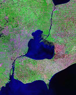
Satellite image: St. Clair River (in the upper half of the image) connects Lake Huron with Lake St. Clair (in the center of the image) |
||
|
Blue Water Bridge at the outflow of the St. Clair River |
||
The St. Clair River (also Saint Clair River ; French Rivière Sainte-Claire ) is 64 km long and part of the 3776 km long St. Lawrence Seaway .
The St. Clair River connects the Upper and Lower Great Lakes . It flows south from the south shore of Lake Huron to Lake St. Clair . In the area of the estuary it divides into different estuary arms and forms a large river delta .
The entire length of the river forms part of the border between the United States and Canada , with Michigan on its west bank and Ontario on the east bank. There are two fixed crossings: the Blue Water Bridge is a road bridge that connects I-94 in Port Huron with the Ontario Highway 402 in Point Edward near the origin of the river, further south Port Huron and Sarnia are also crossed by a St. Clair- Railway tunnel connected.
The river was named after Arthur St. Clair .


