Blue Water Bridge
Coordinates: 42 ° 59 ′ 55 " N , 82 ° 25 ′ 24" W.
|
|
||
|---|---|---|
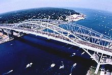
| Blue Water Bridge, the newer bridge in the foreground | ||
| use | 2 × 3 lanes from I-69 / I-94 and Highway 402 | |
| Crossing of | St. Clair River | |
| place | Port Huron and Sarnia | |
| Entertained by | MDOT and Blue Water Bridge Authority | |
| construction |
Gerber girder bridge (westward) Arched girder bridge (eastward) |
|
| overall length | 1883 m (westward) 1862 m (eastward) |
|
| width | 12 m (westward) 16 m (eastward) |
|
| Longest span | 265 m (westward) 281 m (eastward) |
|
| height | 64 m (westward) 71 m (eastward) |
|
| Clear height | 46 m (westward) 47 m (eastward) |
|
| vehicles per day | 14,000 | |
| opening |
October 10, 1938 (westward) July 22nd 1997 (eastward) |
|
| toll | 2.25 USD /2.50 CAD westwards 1.75 USD /2.00 CAD eastwards |
|
| location | ||
|
|
||
The Blue Water Bridge is a two-span bridge that spans the St. Clair River between Port Huron , Michigan and Point Edward , Ontario . The bridge connects Highway 402 with Interstate 69 on the Canadian side and Interstate 94 on the US side of the border. The original building from 1938 is a Gerber beam - truss bridge and the second, much later built carriageway was as arch support bridge with drawstring constructed.
The first bridge was opened to traffic on October 10, 1938. This bridge, designed by Modjeski & Masters , originally had two vehicle lanes and walkways for pedestrians, which were removed in the 1980s to make way for a third lane. The third lane for each direction began in the middle of the bridge to cope with the long backlogs at the border crossings on both sides.
The second bridge, located to the south right next to the first bridge, opened on July 22, 1997. Previously, the customs control facilities and the toll station had been extensively rebuilt. Immediately after the new building was approved, the old bridge was closed for renovation and reopened in 1999; as long as a similar configuration of the three lanes was retained on the new bridge.
The Old Bridge is a Gerber beam - truss bridge m with a total length of 1,883 m and a main span of the 265th The second bridge is an arch bridge with a total length of 1862 m and a main span of 281 m. The construction project was a joint effort by the American architects Modjeski & Masters and the Canadian architects Buckland & Taylor Ltd. During the debate between 1994 and 1995, the public had for the most part in favor of a duplicate of the old bridge over five possibilities for implementation, and every fifth was in favor of a cable-stayed bridge . The Blue Water Bridge Authority had declined both proposals, believing a duplicate would create a false sense of history while the suspension bridge would have architecturally dwarfed the existing bridge. The chosen arch bridge design, which had come in a beaten third place in the polls, was chosen for two reasons. On the one hand, it is an independent structure that fits in architecturally with the original solution; on the other hand, the maintenance costs are lower because the bridge manages with fewer spans.
Together, the two bridges are one of the busiest arteries between the United States and Canada . They are one of the four shortest road links between the New England states and Michigan . The bridge is owned equally by Canada and the United States. The Canadian side is maintained by the Blue Water Bridge Authority and the Michigan Department of Transportation (MDOT) is responsible for the US side. A toll is levied for the maintenance and operation of the bridge .
The Blue Water Bridge was the filming location for the 2000 film The Prophecy with Kim Basinger , in which it was used for a bridge in New York City , and was also featured in the 1994 film Mr. Bill by director Penny Marshall , in which Danny DeVito played.
Web links
- Fishing Reports for the Bluewater Area
- Canadian Blue Water Bridge Authority
- Michigan Blue Water Bridge information
- Information and Tons of Photos of the Original Bridge
- My Favorite Way to Leave Michigan
- Blue Water Bridge. In: Structurae
- Second Blue Water Bridge. In: Structurae
|
None upstream ( Lake Huron ) |
Crossing the St. Clair River |
Downstream St. Clair Tunnel |


