
Niagara River
| Niagara River | ||
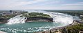
 Satellite image of the Niagara River. The river leaves Lake Erie in the picture below to Lake Ontario in the north. Before reaching Niagara Falls , it flows around Grand Island. The Welland Canal can be seen on the far left of the photo (Source: NASA Visible Earth) |
||
| Data | ||
| Water code | US : 958547 | |
| location |
Canada-USA border ( Ontario (Canada), New York (USA)) |
|
| River system | Saint Lawrence River | |
| Drain over | Saint Lawrence River → Atlantic Ocean | |
| origin |
Lake Erie 43 ° 15 ′ 45 ″ N , 79 ° 4 ′ 13 ″ W. |
|
| Source height | 174 m | |
| muzzle |
Lake Ontario coordinates: 42 ° 53 ′ 3 " N , 78 ° 54 ′ 51" W 42 ° 53 ′ 3 " N , 78 ° 54 ′ 51" W |
|
| Mouth height | 75 m | |
| Height difference | 99 m | |
| Bottom slope | 1.7 ‰ | |
| length | 58 km | |
| Catchment area | 684,000 km² | |
| Drain |
MQ |
5796 m³ / s |
| Big cities | Buffalo | |
| Medium-sized cities | Fort Erie , Niagara Falls (New York) , Niagara Falls (Ontario) | |
| Small towns | Lewiston , Niagara-on-the-Lake | |
| Niagara Falls | ||
The Niagara River [ naɪ̯ˈægəɹə ˈɹɪvəʴ ] (German: Niagara [ ˌniaˈgaːra ]) is a river in North America . It flows from Lake Erie into Lake Ontario . It forms the border between the province of Ontario in Canada and the state of New York in the United States .
River course
The river is about 56 km long. It falls over the Niagara Falls in its course . The falls have shifted approximately seven miles upriver over the past 12,000 years due to erosion of the Niagara strata . The river loses 99 meters in height in its course. There are two large islands in the river, Grand Island and Goat Island , both belonging to the United States. Goat Island and tiny Luna Island divide Niagara Falls into three parts called Horseshoe , Bridal Veil and American Falls . Navy Island is located near the north end of Grand Island, Strawberry Island southeast of Grand Island. Approx. 4 km below (north) Niagara Falls, the river crosses the Whirlpool Rapids .
American and Canadian Niagara Falls as seen from the Skylon Tower

Whirlpool Aero Car over the Whirlpool Rapids

Dam of the Niagara power plant
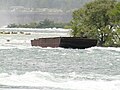
In 1912 the garbage ship ran aground above the falls


Power plants


Hydropower has been used since the 18th century ; from 1759 initially as a drive for water mills , from 1882 then for power generation in the first power station. The system was operated with water from the Hydraulic Canal and was used exclusively to generate direct current for lighting purposes in the immediate vicinity. From 1886 the plans for the Edward Dean Adams Power Plant took place, the power plant for AC voltage was put into operation in 1895 and achieved an output of 78.3 MW and was the world's largest power plant at the time. The Edward Dean Adams Power Plant ceased operations in 1961.
Today there are several power plants along the river: the largest are Sir Adam Beck No. 1 and No. 2 on the Canadian side and the Robert Moses Niagara power plant and the Lewiston pumped storage power plant on the US side. The total installed electrical output of these power plants is around 4.7 GW . This group is one of the largest hydropower plants on earth .
A new power plant tunnel was built from 2005 to 2013. The largest tunnel boring machine in the world at that time was constructed for this 10.2 kilometer long tunnel (diameter 14.4 meters: "Big Becky"). The breakthrough took place in May 2011. The lock gate at the outlet of the tunnel was opened on March 22, 2013.
After water had flowed unhindered through the 10.1 km long water supply tunnel for 24 hours, the structure with a construction volume of € 900 million was considered completed. The flow rate is about 500 cubic meters / second.
shipping
Shipping on the Great Lakes bypasses the river and falls through the Welland Canal . This is located on the Canadian side on the Niagara Peninsula and forms part of the Saint Lawrence Seaway . The Niagara River and its tributary Tonawanda Creek form the last section of the Erie Canal , which flows over the Niagara River into Lake Erie.
Bridges and places on the river
Four crossings across the river simultaneously form border crossings between the USA and Canada.
- The Peace Bridge connects Interstate Highway I-190 in Buffalo , New York with the Queen Elizabeth Way (QEW) in Fort Erie , Ontario.
- The Rainbow Bridge connects Niagara Falls, New York , with Niagara Falls, Ontario .
- The Whirlpool Rapids Bridge , or Whirlpool Bridge , also connects the two cities.
- The Lewiston – Queenston Bridge connects I-190 in Lewiston , New York, with Highway 405 in Queenston , Ontario.
There are also three railroad crossings.
Important cities on the Niagara River are (from the south):
- Buffalo , New York
- Fort Erie , Ontario
- Lewiston , New York
- Niagara Falls , New York
- Niagara Falls , Ontario
- Niagara-on-the-Lake , Ontario
- Queenston , Ontario
history

In the past, the Niagara River was of great strategic importance as part of the waterway from the Saint Lawrence River across the Great Lakes to the northwestern part of what is now the United States. Since there were no usable land routes for a long time, these waterways played a decisive role in war and trade. Niagara Falls was bypassed in the countryside. The first French fortifications were built in 1679, Fort Niagara as the first permanent post in 1726. In 1759, Fort Niagara was conquered by the British, who secured their rule over the Niagara region from there during the Pontiac uprising and during the American Revolutionary War . For a long time, the land on both sides of the banks was only sparsely populated. In addition to individual European settlers and traders, the Indian tribes of the Iroquois League lived there . Although the War of Independence ended in 1783, the British did not vacate Fort Niagara until 1796 after the Jay Treaty was signed . Fort George and Fort Erie were built on the other bank to secure the Canadian border . The flourishing of the Niagara settlements, which accompanied the displacement of the Indians, was interrupted by the war of 1812 , during which the region was a main stage of fighting. The United States made several unsuccessful attempts to invade Canada between 1812 and 1814. A number of battles took place in the immediate vicinity of the river, including the Battle of Queenston Heights on October 13, 1812. The towns and villages on both sides suffered severe damage during the war. While the Americans u. a. Newark (now Niagara-on-the-Lake ) burned down, British troops from Fort Niagara, which they captured in 1813, destroyed the American settlements in their vicinity. After the end of the war, however, it was quickly rebuilt. The river only lost its importance for traffic with the creation of the Welland Canal .
Name example
The New York Central Railroad named their steam locomotives with the Northern (2'D2 ') wheel arrangement with the name Niagara .
Web links
Individual evidence
- ^ Water Resources Data New York Water Year 2003, Volume 3: Western New York , USGS
- ↑ http://www.niagarafrontier.com/power.html#Origins
- ^ Business Men's Association of Niagara Falls, NY: The Water-power of the falls of Niagara applied to manufacturing purposes: the hydraulic tunnel of the Niagara Falls Power Company . Business Men's Association of Niagara Falls, 1890, p. 11.
- ^ Early Electrification of Buffalo. In: Engineering and Technology History Wiki. Retrieved September 30, 2018 .
- ↑ Inventory Nomination Form for National Register of Historical Places. (PDF) National Park Service , accessed December 30, 2013 .
- ↑ http://www.niagarafrontier.com/power.html NIAGARA FALLS HISTORY of POWER (English)
- ↑ in the presence of project participants from the client Ontario Power Generation, the local construction supervision of Hatch Mott MacDonald / Hatch Acres and the Austrian construction company STRABAG
- ^ Niagara Tunnel Project, May 14, 2011, accessed May 15, 2011
- ↑ A Major OPG Clean-Energy Project accessed on May 15, 2011 (English)