
Saint-Crépin-de-Richemont
| Saint-Crépin-de-Richemont | ||
|---|---|---|
|
||
| local community | Brantôme en Périgord | |
| region | Nouvelle-Aquitaine | |
| Department | Dordogne | |
| Arrondissement | Nontron | |
| Coordinates | 45 ° 25 ' N , 0 ° 36' E | |
| Post Code | 24310 | |
| Former INSEE code | 24391 | |
| Incorporation | 1st January 2019 | |
| status | Commune déléguée | |
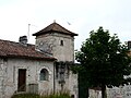
 Saint-Crépin-de-Richemont from the south |
||

Saint-Crépin-de-Richemont ( Occitan Sent Crespin de Richemont ) is a former French community with 223 inhabitants (at January 1, 2017) of the North department Dordogne in the region Nouvelle-Aquitaine . It is integrated into the Périgord-Limousin Regional Nature Park .
etymology
The name of the place is actually a double name, which is composed of the place name Saint-Crépin and the manor Richemont . Saint Crépin or Sent Crespin is derived from Saint Crispinus ; Richemont or riche mont refers to the strategically dominant position of the ridge in the south above the village.
geography
The center of Saint-Crépin-de-Richemont is about seven kilometers northwest of Brantôme and 13 kilometers south-southwest of Nontron .
The place includes the hamlets or individual farms Beleyme, Canteix, Champagne, Chanceland, chez Froment, Francillou, Grange-Haute, La Barde, La Clède, La Forge, La Grèze, La Riboutie, Le Caprice, Le Meyrat, Le Moulin, Le Moulin de la Forge, Le Plessac, Les Âges, Les Baléares, Les Borderies, Les Brageaux, Les Brandes, Les Fregeas, Limeuil, Petit Berger, Pontarnaud, Puylibeau, Puyssegné and Rousselières .
The local area is traversed roughly in the middle of the Boulou , a right tributary of the Dronne . The valley runs in a northeast-southwest direction.
The town center is crossed by the D 98 coming from Quinsac , which connects it to the D 939 from Brantôme to Angoulême , which runs just 1.5 kilometers to the southwest , the main artery from Périgueux to Angoulême. On the eastern border of the local area, the D 675 runs from Nontron to Brantôme. The north-western border is formed by the D 84, a cross-connection from Nontron to Distribution Lac .
Saint-Crépin-de-Richemont is surrounded by the neighboring municipalities and delegated municipalities:
| Mareuil en Périgord | Saint-Front-sur-Nizonne | La Chapelle-Montmoreau |
.svg)
|
Saint-Pancrace | |
| Saint-Félix-de-Bourdeilles |
La Gonterie-Boulouneix (Commune déléguée) |
Cantillac (Commune déléguée) Brantôme en Périgord (Commune déléguée) |
The orographically lowest point of Saint-Crépin-de-Richemont at 120 meters above sea level is at Moulin de la Forge on Boulou on the southwestern edge, the highest point at 246 meters at Puyssegné in the northeast.
geology


The local area of Saint-Crépin-de-Richemont is underlain by sediments of the Upper Cretaceous , which are exposed in the lower elevations along the Boulou. The two ridges in the northwest and southeast consist of tertiary alluvial fans. The flat upper chalk sediments begin in the northeast with the Coniacium followed by the lower and upper Santonium to the southwest. A peculiarity is an N 110 to N 120 trending fault ( Mareuil fault ), which roughly follows the course of the D 939. It is a steep upheaval dipping to the south, along which there was an offset of around 100 meters, so that rocks of the lowest coniacium are now directly next to rocks of the santonium. This fault is a continuation of the Mareuil anticline further to the northwest . The two tertiary alluvial fans are of fluvial origin, they consist of sandstones and conglomerates with quartz and silicified arkose boulders . They are erosion products of the Massif Central and can be up to 70 meters thick. They were poured towards the southwest. Their ages are classified as Eocene or Lowest Oligocene . The hard, conglomerate locations used to be popular as raw material for millstones .
history
The historical traces in Saint-Crépin-de-Richemont can be traced back to the megalithic era, for example a menhir stands not far from Champredon . The extraction of millstones from the old Tertiary alluvial fans took place under the Romans in the 1st century and only came to a standstill in the second half of the 18th century. The church of Saint-Crépin-de-Richemont is late Romanesque . From 1564, Pierre de Bourdeille began building the Château de Richemont .
The decree of November 6, 2018, with effect from January 1, 2019, incorporated Saint-Crépin-de-Richemont as a Commune déléguée together with the former municipalities of Brantôme en Périgord , Eyvirat , La Gonterie-Boulouneix , Cantillac , Sencenac-Puy- de-Fourches and Valeuil for the new Commune nouvelle Brantôme en Périgord .
Population development
After records began, the number of inhabitants rose to a peak of 935 at the beginning of the 19th century. In the following period, a phase of stagnation set in, which caused the number of inhabitants to fall to around 200 before the 1990s with short recovery phases a phase of stabilization set in that continues today.
| year | 1962 | 1968 | 1975 | 1982 | 1990 | 1999 | 2006 | 2011 | 2017 |
|---|---|---|---|---|---|---|---|---|---|
| Residents | 339 | 326 | 246 | 239 | 207 | 202 | 222 | 202 | 223 |

Attractions
- La Barde Castle, castle and fort from the 15th century
- Richemont Castle, 16th century castle, inscribed as a Monument historique since 1927
- Saint-Crépin castle, 19th century castle
- The late Romanesque church of Saint-Crépin and Saint Crépinien
- Menhir of Champredon

The late Romanesque church of Saint-Crépin
Old house next to the church

Castle of Saint-Crépin

La Barde Castle

The west wing of Richemont Castle


.JPG)


Individual evidence
- ^ Website of the Conseil général de la Dordogne with the Occitan community names
- ↑ RECUEIL DES ACTES ADMINISTRATIFS N ° 24-2018-038 ( fr , PDF) Dordogne department. Pp. 13-16. November 6, 2018. Retrieved January 3, 2019.
- ↑ Notice Communale Saint-Crépin-de-Richemont ( fr ) EHESS . Retrieved January 3, 2019.
- ↑ Populations légales 2016 Saint-Crépin-de-Richemont (24391) ( fr ) INSEE . Retrieved January 3, 2019.
- ^ Richemont Castle, Merimée database of the French Ministry of Culture