
Graissessac
| Graissessac | ||
|---|---|---|
.svg)
|
|
|
| region | Occitania | |
| Department | Herault | |
| Arrondissement | Beziers | |
| Canton | Clermont-l'Hérault | |
| Community association | Grand Orb | |
| Coordinates | 43 ° 41 ′ N , 3 ° 6 ′ E | |
| height | 270-1,001 m | |
| surface | 10.03 km 2 | |
| Residents | 654 (January 1, 2017) | |
| Population density | 65 inhabitants / km 2 | |
| Post Code | 34260 | |
| INSEE code | 34117 | |
| Website | http://graissessac.pagesperso-orange.fr/ | |
 Town hall (Mairie) of Graissessac |
||

Graissessac ( Occitan : Graisseçac ) is a southern French commune in the department of Herault in the region Occitania . It has 654 inhabitants (as of January 1, 2017). The municipality belongs to the arrondissement of Béziers and the canton of Clermont-l'Hérault (until 2015: canton of Bédarieux ). The inhabitants are called Graissessacois .
geography
Graissessac is located about 38 kilometers north-northwest of Béziers on the Clédou , a tributary of the Mare . Graissessac is surrounded by the neighboring communities of Avène in the north, Camplong in the east and north-east, Saint-Étienne-Estréchoux in the south, Saint-Gervais-sur-Mare in the west and south-west and Mélagues in the north-west.
history
Graissessac is an old mining town. Mining was already practiced here during the Gallo-Roman period. In 1962 the last coal miners drove into the open pit here.
Population development
| 1962 | 1968 | 1975 | 1982 | 1990 | 1999 | 2006 | 2012 |
|---|---|---|---|---|---|---|---|
| 614 | 1,510 | 1,134 | 924 | 687 | 632 | 685 | 717 |
| Source: Cassini and INSEE | |||||||
Sons and daughters of the town
- Michel Maffesoli (1944 *), sociologist
- Marc Azéma (1905–1954), racing car driver
Attractions
- Saint-Sauveur church
- protestant church
- "Castle" of the miners
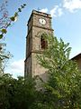
Saint-Sauveur church

protestant church

Castle of the miners
_l%27Eglise.jpg)

