Capestang
|
Capestang Capestanh |
||
|---|---|---|

|
|
|
| region | Occitania | |
| Department | Herault | |
| Arrondissement | Beziers | |
| Canton | Saint-Pons-de-Thomières | |
| Community association | Sud-Herault | |
| Coordinates | 43 ° 20 ' N , 3 ° 3' E | |
| height | 0-120 m | |
| surface | 39.56 km 2 | |
| Residents | 3,233 (January 1, 2017) | |
| Population density | 82 inhabitants / km 2 | |
| Post Code | 34310 | |
| INSEE code | 34052 | |
| Website | http://www.ville-capestang.fr/ | |
 Capestang City Hall |
||
Capestang ( Occitan : Capestanh ) is a French commune with 3233 inhabitants (as of January 1, 2017) in the Hérault department in the Occitanie region . It belongs to the arrondissement of Béziers and the canton of Saint-Pons-de-Thomières . The inhabitants are called Capestanais (es) .
geography
Capestang is about eleven kilometers west-southwest of Béziers on the border with the Aude department . Capestang is surrounded by the neighboring communities of Puisserguier in the north, Maureilhan in the north-east, Montady in the east, Poilhes in the south-east, Nissan-lez-Enserune in the south and south-east, Montels in the south and south-west, Ouveillan in the south-west and Quarante in the west and north-west. The community is the ship channel Canal du Midi traverses.
Population development
| year | 1962 | 1968 | 1975 | 1982 | 1990 | 1999 | 2006 | 2017 |
| Residents | 3019 | 3014 | 2548 | 2675 | 2903 | 3007 | 3010 | 3223 |
Attractions
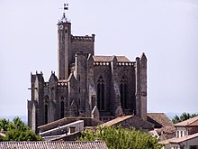
- Collegiate Saint-Étienne from the 13th century with a 43 meter high bell tower, monument historique since 1906
- Castle Capestang (Castle of the Archbishop of Narbonne) from the 14th and 15th centuries, monument historique since 1995
- 17th century Canal du Midi and the Étang de Capestang wetland


