
Lézignan-la-Cèbe
|
Lézignan-la-Cèbe Lesinhan la Ceba |
||
|---|---|---|
.svg)
|
|
|
| region | Occitania | |
| Department | Herault | |
| Arrondissement | Beziers | |
| Canton | Mèze | |
| Community association | Hérault Méditerranée | |
| Coordinates | 43 ° 30 ' N , 3 ° 26' E | |
| height | 7-91 m | |
| surface | 6.13 km 2 | |
| Residents | 1,546 (January 1, 2017) | |
| Population density | 252 inhabitants / km 2 | |
| Post Code | 34120 | |
| INSEE code | 34136 | |
| Website | http://www.mairie-lezignan-la-cebe.fr/ | |
 Town hall (Mairie) of Lézignan-la-Cèbe |
||

Lézignan-la-Cèbe ( Occitan : Lesinhan la Ceba ) is a place and a municipality in the south of France with 1,546 inhabitants (as of January 1, 2017) in the Hérault department in the Occitanie region . The municipality belongs to the arrondissement of Béziers and the canton of Mèze (until 2015: canton of Montagnac ). The inhabitants are called Lézignanais .
location
Lézignan-la-Cèbe is located about 24 kilometers northeast of Béziers and about 37 kilometers west-southwest of Montpellier am Hérault . Lézignan-la-Cèbe is surrounded by the neighboring communities of Nizas in the north and northwest, Cazouls-d'Hérault in the east and northeast, Nizas in the south and southeast, and Pézenas in the south and west.
The A75 autoroute runs through the municipality .
Population development
| year | 1962 | 1968 | 1975 | 1982 | 1990 | 1999 | 2006 | 2017 |
| Residents | 767 | 736 | 712 | 838 | 977 | 1013 | 1184 | 1546 |
| Sources: Cassini and INSEE | ||||||||
Attractions
- Notre-Dame church
- Les Ribes Castle, built in 1617
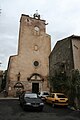
Notre-Dame church

Les Ribes Castle


Personalities
- Olivier Lefèvre d'Ormesson (1918–2012), politician (FN), member of the European Parliament (1979–1989)
Trivia
Lézignan-la-Cèbe is known for the stone tools found here by hominids, which can be dated to an age of around 1.5 million years.