
Hérault (river)
| Herault | ||
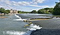
 Dilapidated Roman bridge near Saint-Thibéry |
||
| Data | ||
| Water code | FR : Y2-0200 | |
| location | France , Occitania region | |
| River system | Herault | |
| source | at Col de Prat Peyrot , in the municipality of Valleraugue 44 ° 6 ′ 55 ″ N , 3 ° 33 ′ 0 ″ E |
|
| Source height | approx. 1370 m | |
| muzzle | at Le Grau d'Agde in the Mediterranean Coordinates: 43 ° 16 '57 " N , 3 ° 26' 38" E, 43 ° 16 '57 " N , 3 ° 26' 38" E |
|
| Mouth height | approx. 0 m | |
| Height difference | approx. 1370 m | |
| Bottom slope | approx. 9.3 ‰ | |
| length | 148 km | |
| Catchment area | 2582 km² | |
| Left tributaries | Rieutord | |
| Right tributaries | Arre , Vis , Lergue , Boyne , Peyne , Thongue | |
| Medium-sized cities | Agde | |
| Small towns | Pézenas | |
| Navigable | between the mouth and the place Bessan | |
The Hérault ( Occitan : Erau , from Latin : Arauris ) is a river in southern France ( Occitania region ), which gave the Hérault its name.
geography
It rises in the southern Cevennes , in the massif of Mont Aigoual . Its source is located in the Col de Prat Peyrot , in the municipality of Valleraugue , at an altitude of about 1370 meters. It generally drains south and flows into the Mediterranean after 148 kilometers at Grau d'Agde and La Tamarissière , two districts of Agde . The Hérault flows through the Gard and Hérault departments on its way .
- Places on the river
(Order in flow direction)
- Valleraugue
- Ganges
- Laroque
- Saint-Bauzille
- Saint-Guilhem
- Aniane
- Gignac
- Canet
- Paulhan
- Pézenas
- Saint-Thibéry
- Florensac
- Bessan
- Agde
- Grau d'Agde
- shipping
The Hérault is navigable by boat from the mouth upstream, via the round lock of Agde , to the town of Bessan . In Agde the river crosses the Canal du Midi at the same level.

The newer bridges from the Pont du Diable seen from

Herault gorges

Bridge at Gignac

The navigable part
The Hérault near Agde


