Lergue
| Lergue | ||
|
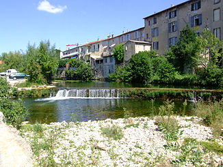
The Lergue crosses Lodève |
||
| Data | ||
| Water code | FR : Y22-0400 | |
| location | France , Occitania region | |
| River system | Herault | |
| Drain over | Hérault → Mediterranean | |
| source | in the municipality of Romiguières, 43 ° 49 ′ 8 ″ N , 3 ° 14 ′ 44 ″ E |
|
| Source height | approx. 810 m | |
| muzzle | in the municipality of Pouzols in the Hérault coordinates: 43 ° 37 ′ 0 ″ N , 3 ° 29 ′ 45 ″ E, 43 ° 37 ′ 0 ″ N , 3 ° 29 ′ 45 ″ E |
|
| Mouth height | approx. 27 m | |
| Height difference | approx. 783 m | |
| Bottom slope | approx. 17 ‰ | |
| length | 45 km | |
| Catchment area | 428 km² | |
| Drainage at the Lodève gauge |
MQ |
4.7 m³ / s |
| Left tributaries | Marguerite | |
| Right tributaries | Soulondres , Aubaygues , Salagou | |
| Small towns | Lodève | |
The Lergue is a river in southern France that runs in the Hérault department in the Occitania region . It rises on the Causse du Larzac , in the municipality of Romiguières , generally drains in a south-east to south direction, flows around the Lac du Salagou to the north-east and flows 45 kilometers into the Pouzols municipality as a right tributary into the Hérault .
Places on the river
(Order in flow direction)
See also
Web links
Commons : Lergue - collection of images, videos and audio files
Individual evidence
- ↑ a b geoportail.fr (1: 16,000)
- ↑ a b c The information on the length of the river is based on the information about the Lergue from SANDRE (French), accessed on April 17, 2011, rounded to full kilometers.
- ↑ hydro.eaufrance.fr (station: Y2214010 , option: Synthèse )
