
Ceyras
|
Ceyras Seiraç |
||
|---|---|---|
.svg)
|
|
|
| region | Occitania | |
| Department | Herault | |
| Arrondissement | Lodève | |
| Canton | Clermont-l'Hérault | |
| Community association | Clermontais | |
| Coordinates | 43 ° 39 ′ N , 3 ° 28 ′ E | |
| height | 39–152 m | |
| surface | 6.96 km 2 | |
| Residents | 1,396 (January 1, 2017) | |
| Population density | 201 inhabitants / km 2 | |
| Post Code | 34800 | |
| INSEE code | 34076 | |
 Town hall (Mairie) of Ceyras |
||

Ceyras ( Occitan : Seiraç ) is a place and a municipality in the south of France with 1,396 inhabitants (as of January 1, 2017) in the Hérault department in the Occitania region (previously Languedoc-Roussillon ). The municipality belongs to the arrondissement of Lodève and the canton of Clermont-l'Hérault . The inhabitants are called Ceyradais .
location
Ceyras is located about 34 kilometers west-northwest of Montpellier . Ceyras is surrounded by the neighboring communities of Saint-Guiraud in the north and north-west, Saint-Félix-de-Lodez in the north, Saint-André-de-Sangonis in the east, Brignac in the south, Clermont-l'Hérault in the south and south-west, Lacoste in the West and Le Bosc in the northwest.
The motorway triangle of the A75 autoroute with the A750 autoroute is located in the municipality .
Population development
| year | 1962 | 1968 | 1975 | 1982 | 1990 | 1999 | 2006 | 2017 |
| Residents | 503 | 503 | 513 | 602 | 681 | 725 | 895 | 1396 |
| Sources: Cassini and INSEE | ||||||||
Attractions
- Saint-Saturnin Church
- Notre-Dame-de-l'Hortus chapel from the 14th / 15th centuries Century, Monument historique
- Saint-Pierre-de-Léneyrac chapel

Saint-Saturnin Church
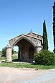
Notre-Dame-de-l'Hortus chapel

