Saint-Gély-du-Fesc
|
Saint-Gély-du-Fesc Sant Geli dah Fesc |
||
|---|---|---|

|
|
|
| region | Occitania | |
| Department | Herault | |
| Arrondissement | Lodève | |
| Canton | Saint-Gély-du-Fesc | |
| Community association | Grand Pic Saint Loup | |
| Coordinates | 43 ° 42 ' N , 3 ° 48' E | |
| height | 71-264 m | |
| surface | 16.51 km 2 | |
| Residents | 9,795 (January 1, 2017) | |
| Population density | 593 inhabitants / km 2 | |
| Post Code | 34980 | |
| INSEE code | 34255 | |
| Website | http://www.saintgelydufesc.com/ | |
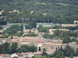
 Center of Saint-Gély-du-Fesc |
||
Saint-Gély-du-Fesc ( Occitan : Sant Geli fotograf Fesc ) is a municipality with 9795 inhabitants (as of January 1, 2017) in the Hérault department in the Occitania region . Saint-Gély-du-Fesc in the arrondissement of Lodève and in the canton of Saint-Gély-du-Fesc . The inhabitants are called Saint-Gillois .
geography
Saint-Gély-du-Fesc is about ten kilometers north of Montpellier on the Mosson . Saint-Gély-du-Fesc is surrounded by the neighboring communities of Les Matelles in the north, Saint-Clément-de-Rivière in the east, Grabels in the south, Combaillaux in the southwest and Murles in the west.
Population development
| year | 1962 | 1968 | 1975 | 1982 | 1990 | 1999 | 2010 | 2017 |
| Residents | 528 | 907 | 2055 | 3714 | 5936 | 7625 | 8821 | 9795 |
| Sources: Cassini and INSEE | ||||||||
Attractions
- Saint-Gilles Church, Monument historique
- Archaeological sites near Vautes, Rouergas and the Colline de l'Homme Mort
Personalities
- Georges Brassens (1921–1981), chanson singer
- Ptiluc (* 1956), Belgian designer
- Frédéric Volle (* 1966), handball player
- François Trinh-Duc (* 1986), rugby player
Web links
Commons : Saint-Gély-du-Fesc - Collection of images, videos and audio files

