Grabels
| Grabels | ||
|---|---|---|

|
|
|
| region | Occitania | |
| Department | Herault | |
| Arrondissement | Montpellier | |
| Canton | Montpellier-1 | |
| Community association | Montpellier Méditerranée Métropole | |
| Coordinates | 43 ° 39 ′ N , 3 ° 48 ′ E | |
| height | 50-167 m | |
| surface | 16.24 km 2 | |
| Residents | 8,430 (January 1, 2017) | |
| Population density | 519 inhabitants / km 2 | |
| Post Code | 34790 | |
| INSEE code | 34116 | |
| Website | http://www.ville-juvignac.fr/ | |
 Saint-Julien-et-Sainte-Basilisse church |
||
Grabels is a French commune with 8,430 inhabitants (as of January 1, 2017) in the Hérault department in the Occitania region ; it belongs to the arrondissement of Montpellier and the canton of Montpellier-1 .
geography
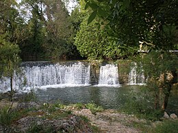
Grabels is surrounded by the neighboring communities Combaillaux in the north, Saint-Gély-du-Fesc in the northeast, Saint-Clément-de-Rivière in the east, Montpellier in the southeast, Juvignac in the south, Saint-Georges-d'Orques and Montarnaud in the southwest as well Valhauquès in the north-west. The Mosson River flows through Grabels . The Source de l'Avy , which flows into the Mosson, also rises here.
Grabels belongs to the Vin de pays des Collines de la Moure wine-growing region .
Population development
| year | 1962 | 1968 | 1975 | 1982 | 1990 | 1999 | 2006 | 2017 |
| Residents | 835 | 1020 | 1537 | 2527 | 3130 | 5438 | 5906 | 8430 |
Attractions
- Saint-Julien-et-Sainte-Basilisse church
- Tower de la Valsière
Personalities
- Joseph Delteil (1894–1978), writer
- William "Meyna'ch" Roussel (* 1976), French black metal musician and founding member of the band Mütiilation
Web links
Commons : Grabels - collection of images, videos and audio files

