Pérols
|
Pérols Peròus |
||
|---|---|---|

|
|
|
| region | Occitania | |
| Department | Herault | |
| Arrondissement | Montpellier | |
| Canton | Lattes | |
| Community association | Montpellier Méditerranée Métropole | |
| Coordinates | 43 ° 34 ′ N , 3 ° 57 ′ E | |
| height | 0-12 m | |
| surface | 6.01 km 2 | |
| Residents | 8,985 (January 1, 2017) | |
| Population density | 1,495 inhabitants / km 2 | |
| Post Code | 34470 | |
| INSEE code | 34198 | |
| Website | http://www.ville-perols.fr/ | |
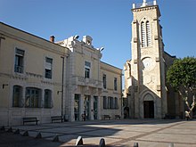
Pérols ( okzitan. : Peròus ) is a southern French town in the Hérault department in the region of Occitan in southern France . Pérols belongs to the arrondissement of Montpellier and the canton of Lattes . It has 8985 inhabitants (as of January 1, 2017), which are called "Péroliens" .
geography
Pérols is located about 8.5 kilometers southeast of Montpellier behind the spits of the Golfe du Lion . The municipality extends over parts of the lagoons Étang de l'Or and Étang du Méjean .
Lattes is to the west and northwest , Mauguio to the northeast and east and Palavas-les-Flots to the south.
history
The place was first mentioned in documents in 804 ( Perairolum ).
Population development
| 1962 | 1968 | 1975 | 1982 | 1990 | 1999 | 2006 | 2011 |
|---|---|---|---|---|---|---|---|
| 1351 | 2203 | 3440 | 4422 | 6595 | 7731 | 8545 | 8547 |
Attractions
- Saint-Sixte church from the 19th century
- town hall
In Pérols there is the Park & Suites Arena event hall (formerly: Arena Montpellier ), built between 2008 and 2010, with 9,000 to 14,000 seats.
Parish partnership
A partnership has existed with the Hessian community of Flörsheim am Main , Germany, since 1992.

