Saint-Geniès-des-Mourgues
|
Saint-Geniès-des-Mourgues Sant Ginièis de las Morgas |
||
|---|---|---|

|
|
|
| region | Occitania | |
| Department | Herault | |
| Arrondissement | Montpellier | |
| Canton | Le Crès | |
| Community association | Montpellier Méditerranée Métropole | |
| Coordinates | 43 ° 42 ' N , 4 ° 2' E | |
| height | 23-90 m | |
| surface | 11.37 km 2 | |
| Residents | 1,876 (January 1, 2017) | |
| Population density | 165 inhabitants / km 2 | |
| Post Code | 34160 | |
| INSEE code | 34256 | |
| Website | http://www.stgenies.org/ | |
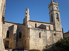
 View of Saint-Geniès-des-Mourgues |
||
Saint-Geniès-des-Mourgues ( Occitan : Sant Ginièis de las Morgas ) is a French commune with 1,876 inhabitants (as of January 1, 2017) in the Hérault department in the Occitanie region . It belongs to the arrondissement of Montpellier and the canton of Le Crès (until 2015: canton of Castries ). The inhabitants are called Saint-Geniérois .
geography
Saint-Geniès-des-Mourgues is about 15 kilometers northeast of Montpellier . Saint-Geniès-des-Mourgues is surrounded by the neighboring communities of Beaulieu in the north and north-west, Restinclières in the north, Entre-Vignes with Saint-Christol in the east and north-east, Lunel-Viel in the east and south-east, Valergues in the south-east, Saint-Brès in the South, Castries to the west and southwest and Sussargues to the northwest. The A9 autoroute runs along the south and south-east of the municipality .
history
The establishment of the place goes back to the establishment of the Saint-Geniès monastery in 1019.
Population development
| Population development | ||||||||
|---|---|---|---|---|---|---|---|---|
| year | 1962 | 1968 | 1975 | 1982 | 1990 | 1999 | 2006 | 2017 |
| Residents | 694 | 862 | 834 | 1112 | 1415 | 1509 | 1596 | 1876 |
| Sources: Cassini and INSEE | ||||||||
Attractions
- Saint-Geniès monastery church from the 11th century
- Saint-Geniès quarries
Personalities
- Albert Ayme (1920–2012), painter and sculptor

