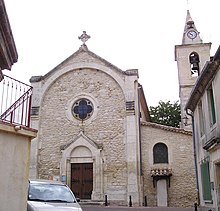
Saint-Aunès
| Saint-Aunès | ||
|---|---|---|

|
|
|
| region | Occitania | |
| Department | Herault | |
| Arrondissement | Montpellier | |
| Canton | Mauguio | |
| Community association | Pays de l'Or | |
| Coordinates | 43 ° 38 ′ N , 3 ° 58 ′ E | |
| height | 13-60 m | |
| surface | 12.32 km 2 | |
| Residents | 3,439 (January 1, 2017) | |
| Population density | 279 inhabitants / km 2 | |
| Post Code | 34130 | |
| INSEE code | 34240 | |
| Website | http://www.saint-aunes.fr/ | |
Saint-Aunès ( Occitan : Sant Aunès ) is a commune in the department of Herault in the region Occitan in southern France . It has 3439 inhabitants (as of January 1, 2017). Saint-Aunès belongs to the arrondissement of Montpellier and the canton of Mauguio .
geography
Saint-Aunès is about eight kilometers northeast of Montpellier . Saint-Aunès is surrounded by the neighboring communities of Vendargues in the north, Baillargues in the east and northeast, Mauguio in the south and southeast, Montpellier in the southwest, Castelnau-le-Lez in the west and Le Crès in the northwest.
The A9 car route runs through the municipality . The station is on the Tarascon – Sète-Ville line .
Population development
| 1962 | 1968 | 1975 | 1982 | 1990 | 1999 | 2006 | 2017 |
|---|---|---|---|---|---|---|---|
| 473 | 525 | 536 | 1162 | 2027 | 2825 | 2990 | 3439 |
Attractions
- Saint-Aunès church
- Solar power plant
Personalities
- François de Baschi (1710–1777), diplomat
- Albert Dubout (1905–1976), poster artist and caricaturist
Web links
Commons : Saint-Aunès - Collection of images, videos and audio files

