Boisseron
| Boisseron | ||
|---|---|---|

|
|
|
| region | Occitania | |
| Department | Herault | |
| Arrondissement | Montpellier | |
| Canton | Lunel | |
| Community association | Pays de Lunel | |
| Coordinates | 43 ° 46 ' N , 4 ° 5' E | |
| height | 19-77 m | |
| surface | 7.46 km 2 | |
| Residents | 1,989 (January 1, 2017) | |
| Population density | 267 inhabitants / km 2 | |
| Post Code | 34160 | |
| INSEE code | 34033 | |
| Website | http://www.boisseron.com/ | |
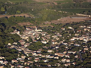
 Aerial view of Boisseron |
||
Boisseron is a French commune with 1,989 inhabitants (as of January 1, 2017) in the Hérault department in the Occitanie region . It belongs to the arrondissement of Montpellier and the canton of Lunel . The inhabitants are called Boisseronais .
geography
Boisseron is located about ten kilometers east-northeast of Montpellier on the Bénovie river , which flows into the Vidourle here , which in turn forms the eastern municipal boundary. Boisseron is surrounded by the neighboring communities of Sommières in the north and east, Saint-Sériès in the south-east, Entre-Vignes with Saint-Christol in the south, Restinclières in the south-west and Saussines in the west.
The former route nationale 110 (today's D610) runs through the municipality .
Population development
| 1962 | 1968 | 1975 | 1982 | 1990 | 1999 | 2006 | 2017 |
|---|---|---|---|---|---|---|---|
| 560 | 583 | 643 | 864 | 981 | 1151 | 1319 | 1989 |
Attractions
- Roman bridge over the Bénovie from the first century AD ( Monument historique )
- Catholic Church from the 19th century
- 19th century Protestant church
- town hall
- Stone gate
- Boisseron Castle
Web links
Commons : Boisseron - collection of images, videos and audio files
