Bénovie
| Bénovie | ||
|
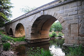
Roman bridge over the river at Boisseron |
||
| Data | ||
| Water code | FR : Y3450600 | |
| location | France , Occitania region | |
| River system | Vidourle | |
| Drain over | Vidourle → Mediterranean | |
| source | in the municipality of Sainte-Croix-de-Quintillargues 43 ° 45 ′ 40 ″ N , 3 ° 54 ′ 23 ″ E |
|
| Source height | approx. 125 m | |
| muzzle | in the municipality of Boisseron Coordinates: 43 ° 45 ′ 38 " N , 4 ° 5 ′ 29" E 43 ° 45 ′ 38 " N , 4 ° 5 ′ 29" E |
|
| Mouth height | approx. 18 m | |
| Height difference | approx. 107 m | |
| Bottom slope | approx. 4.7 ‰ | |
| length | approx. 23 km | |
The Bénouvie is a river in France , who in the department of Herault in the regions Okzitanien runs and a few kilometers the border with neighboring Gard forms.
course
It rises in the municipal area of Sainte-Croix-de-Quintillargues and first drains northwards in its upper reaches, then turns generally east to southeast and after a total of around 23 kilometers flows into the Vidourle as a right tributary in the municipality of Boisseron .
Places on the river
(Order in flow direction)
Attractions
- Bridge over the river at Boisseron of Roman origin, Monument historique
Web links
Commons : Bénovie - collection of images, videos and audio files
Individual evidence
- ↑ Source height according to geoportail.gouv.fr
- ↑ mouth height according to geoportail.gouv.fr
- ↑ Bénovie at SANDRE (French)
- ^ Roman bridge in the Base Mérimée of the French Ministry of Culture (French)
