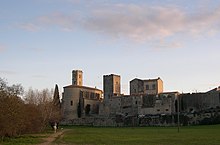
Cournonterral
|
Cournonterral Cornonterralh |
||
|---|---|---|

|
|
|
| region | Occitania | |
| Department | Herault | |
| Arrondissement | Montpellier | |
| Canton | Pignan | |
| Community association | Montpellier Méditerranée Métropole | |
| Coordinates | 43 ° 34 ' N , 3 ° 43' E | |
| height | 29-320 m | |
| surface | 28.62 km 2 | |
| Residents | 6,110 (January 1, 2017) | |
| Population density | 213 inhabitants / km 2 | |
| Post Code | 34660 | |
| INSEE code | 34088 | |
| Website | www.ville-cournonterral.fr/ | |
 Town Hall ( Hôtel de ville ) |
||
Cournonterral ( Occitan : Cornonterralh ) is a French commune in the Hérault department in the Occitanie region . It has 6110 inhabitants (as of January 1, 2017) and belongs to the Arrondissement of Montpellier and the Canton of Pignan . The inhabitants are called Cournonterralais .
geography
Cournonterral is about fourteen kilometers west-southwest of Montpellier at the foot of the Gardiole massif, an extension of the Provencal-Pyrenees chain. The Coulazou River flows through the municipality. Cournonterral is surrounded by the neighboring communities of Saint-Paul-et-Valmalle in the north, Murviel-lès-Montpellier in the northeast, Pignan in the east, Fabrègues in the southeast, Cournonsec in the south, Montbazin in the southwest and Aumelas in the west.
Cournonterral is part of the Vin de pays des Collines de la Moure wine-growing region .
Population development
| 1962 | 1968 | 1975 | 1982 | 1990 | 1999 | 2006 | 2017 |
|---|---|---|---|---|---|---|---|
| 1887 | 2088 | 2460 | 3062 | 4095 | 5069 | 5507 | 6110 |
Attractions
- Saint-Pierre church
- town hall
- Château Mallet
- Saracen tower
Community partnerships
- Bot , Catalonia, Spain
Personalities
- Émile Blavet (1828-1924), journalist

