
Entre-Vignes
| Entre-Vignes | ||
|---|---|---|
|
||
| region | Occitania | |
| Department | Herault | |
| Arrondissement | Montpellier | |
| Canton | Lunel | |
| Community association | Communauté de communes du Pays de Lunel | |
| Coordinates | 43 ° 44 ' N , 4 ° 5' E | |
| height | 15-92 m | |
| surface | 16.80 km 2 | |
| Residents | 2,136 (January 1, 2017) | |
| Population density | 127 inhabitants / km 2 | |
| Post Code | 34400 | |
| INSEE code | 34246 | |

Entre-Vignes is a French commune with 2,136 inhabitants (as of January 1, 2017) in the Hérault department in the Occitanie region . It belongs to the arrondissement of Montpellier and the canton of Lunel .
It was created as Commune nouvelle with effect from January 1, 2019 by amalgamating the previous municipalities of Saint-Christol and Vérargues , which have the status of a Commune déléguée in the new municipality . The administrative headquarters are in Saint-Christol.
structure
| District | former INSEE code |
Area (km²) | Population as of January 1, 2017 |
|---|---|---|---|
| Saint-Christol (administrative headquarters) | 34246 | 11.29 | 1,389 |
| Vérargues | 34330 | 5.51 | 747 |
geography
The municipality is located around 20 kilometers northeast of Montpellier . The municipality is affected by the Dardaillon River . The A9 motorway runs just outside the southern border . Neighboring municipalities are Boisseron in the north, Saint-Sériès in the northeast, Saturargues in the east, Lunel-Viel in the southeast, Saint-Geniès-des-Mourgues in the southwest and Restinclières in the west. On more than 90% of the community area, wine belonging to the Languedoc wine-growing region is grown .
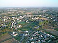
Saint-Christol
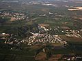
Vérargues


Web links
Individual evidence
- ↑ Decree of the Prefecture No. 2018-01-1424 on the creation of the Commune nouvelle Entre-Vignes of December 13, 2018.
- ↑ current population according to INSEE