Prades-le-Lez
|
Prades-le-Lez Pradas de Les |
||
|---|---|---|

|
|
|
| region | Occitania | |
| Department | Herault | |
| Arrondissement | Montpellier | |
| Canton | Saint-Gély-du-Fesc | |
| Community association | Montpellier Méditerranée Métropole | |
| Coordinates | 43 ° 42 ' N , 3 ° 52' E | |
| height | 53-134 m | |
| surface | 8.88 km 2 | |
| Residents | 5,467 (January 1, 2017) | |
| Population density | 616 inhabitants / km 2 | |
| Post Code | 34730 | |
| INSEE code | 34217 | |
| Website | http://www.prades-le-lez.fr/ | |
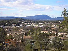
Prades-le-Lez ( Occitan : Pradas de Les ) is a French commune with 5467 inhabitants (as of January 1, 2017) in the Hérault department in the Occitanie region . It belongs to the arrondissement of Montpellier and the canton of Saint-Gély-du-Fesc . The inhabitants are called Pradéens .
geography
At Prades-le-Lez, about twelve kilometers north of Montpellier , the Lirou River flows into the Lez . The Pic Saint-Loup rises above Prades-le-Lez . Prades-le-Lez is surrounded by the neighboring municipalities of Le Triadou in the north, Assas in the east and northeast, Saint-Vincent-de-Barbeyrargues in the east, Montferrier-sur-Lez in the south, Saint-Clément-de-Rivière in the west and Les Matelles in the northwest.
Population development
| Population development | ||||||||
|---|---|---|---|---|---|---|---|---|
| year | 1962 | 1968 | 1975 | 1982 | 1990 | 1999 | 2006 | 2017 |
| Residents | 523 | 704 | 917 | 1538 | 3604 | 4361 | 4494 | 5467 |
Attractions
- Church built in 1891 on the site of the earlier 12th century Romanesque church (Saint-Jacques-le-Majeur church)
- Former Restinclières Castle, built under Louis XIV to replace the old castle
Web links
Commons : Prades-le-Lez - collection of images, videos and audio files


