
Assas
|
Assas Assas |
||
|---|---|---|
.svg)
|
|
|
| region | Occitania | |
| Department | Herault | |
| Arrondissement | Lodève | |
| Canton | Saint-Gély-du-Fesc | |
| Community association | Grand Pic Saint Loup | |
| Coordinates | 43 ° 42 ' N , 3 ° 54' E | |
| height | 59-164 m | |
| surface | 19.11 km 2 | |
| Residents | 1,520 (January 1, 2017) | |
| Population density | 80 inhabitants / km 2 | |
| Post Code | 34820 | |
| INSEE code | 34014 | |
| Website | http://www.assas.fr/ | |

Assas ( Occitan : Assàs ) is a French commune with 1,520 inhabitants (as of January 1, 2017) in the Hérault department in the Occitanie region . It belongs to the arrondissement of Lodève and the canton of Saint-Gély-du-Fesc (until 2015: canton of Castries ). The inhabitants are called Assadins .
geography
Assas is about ten kilometers north of Montpellier . Assas is surrounded by the neighboring communities of Saint-Mathieu-de-Tréviers in the north, Guzargues in the east and north-east, Teyran in the east and south-east, Clapiers in the south and south-west, Prades-le-Lez and Saint-Vincent-de-Barbeyrargues in the west as well Le Triadou in the northwest.
Population development
| Population development | ||||||||
|---|---|---|---|---|---|---|---|---|
| year | 1962 | 1968 | 1975 | 1982 | 1990 | 1999 | 2006 | 2017 |
| Residents | 352 | 352 | 506 | 815 | 992 | 1,305 | 1,483 | 1520 |
| Sources: Cassini and INSEE | ||||||||
Attractions
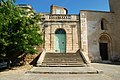
- Romanesque church of Saint-Martial from the 11th / 12th centuries. Century, since 1987 Monument historique
- Assas Castle from the 18th century, built on the remains of the former castle complex
- Remains of the earlier fortifications
- old town center

Saint-Martial church
Assas Castle
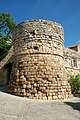
Tower of the former fortification


Web links
Commons : Assas (Hérault) - Collection of images, videos and audio files