Canet (Hérault)
| Canet | ||
|---|---|---|

|
|
|
| region | Occitania | |
| Department | Herault | |
| Arrondissement | Lodève | |
| Canton | Clermont-l'Hérault | |
| Community association | Clermontais | |
| Coordinates | 43 ° 36 ' N , 3 ° 29' E | |
| height | 23-57 m | |
| surface | 7.32 km 2 | |
| Residents | 3,503 (January 1, 2017) | |
| Population density | 479 inhabitants / km 2 | |
| Post Code | 34800 | |
| INSEE code | 34051 | |
| Website | http://www.canet-herault.com/ | |
 Town Hall ( Hôtel de ville ) |
||
Canet is a municipality in the south of France with 3503 inhabitants (as of January 1, 2017) in the Hérault department in the Occitania region . Canet belongs to the arrondissement of Lodève and the canton of Clermont-l'Hérault . The inhabitants are called Canétois .
geography
The river Hérault limits the municipality to the east. Canet is surrounded by the neighboring communities of Saint-André-de-Sangonis in the north, Pouzols in the north-east, Le Pouget in the east, Tressan in the south, Aspiran in the south-west, Nébian and Clermont-l'Hérault in the west and Brignac in the north-west.
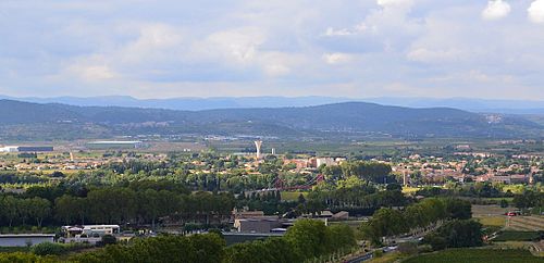
View of Canet
Population development
| year | 1962 | 1968 | 1975 | 1982 | 1990 | 1999 | 2006 | 2017 |
| Residents | 960 | 1022 | 1061 | 1206 | 1402 | 1598 | 2868 | 3503 |
Attractions
- Saint-Martin church from the 13th century, rededicated in 1761
- Notre-Dame-de-l'Assomption church, former Dominican church, choir from 1636, bell tower from 1838
- Canet Castle, built as a fortification in the 14th century
Parish partnership
There is a partnership with the Spanish municipality of Canet de Berenguer in the province of Valencia.
Web links
Commons : Canet - collection of images, videos and audio files


