
Moulès-et-Baucels
|
Moulès-et-Baucels Molés e Baucèls |
||
|---|---|---|
.svg)
|
|
|
| region | Occitania | |
| Department | Herault | |
| Arrondissement | Lodève | |
| Canton | Lodève | |
| Community association | Cévennes Gangeoises et Suménoises | |
| Coordinates | 43 ° 57 ' N , 3 ° 44' E | |
| height | 156-727 m | |
| surface | 22.78 km 2 | |
| Residents | 877 (January 1, 2017) | |
| Population density | 38 inhabitants / km 2 | |
| Post Code | 34190 | |
| INSEE code | 34174 | |
| Website | http://moulesetbaucels.online.fr/ | |
 Town hall (Mairie) of Moulès-et-Baucels |
||

Moulès-et-Baucels ( Occitan Molés e Baucèls ) is a place and a municipality in the south of France with 877 inhabitants (as of January 1, 2017) in the Hérault department in the Occitania region . The municipality belongs to the arrondissement of Lodève and the canton of Lodève (until 2015: canton of Ganges ). The inhabitants are called Moucelois or Baucelois .
location
Moulès-et-Baucels is the northernmost municipality in the Hérault department. It is located about 39 kilometers north-northwest of Montpellier in the southern foothills of the Cevennes . Moulès-et-Baucels is surrounded by the neighboring municipalities of Sumène in the north, La Cadière-et-Cambo in the east, Montoulieu in the southeast, Saint-Bauzille-de-Putois and Laroque in the south and Ganges in the west.
Population development
| year | 1962 | 1968 | 1975 | 1982 | 1990 | 1999 | 2006 | 2017 | ||||
| Residents | 65 | 77 | 128 | 190 | 297 | 598 | 722 | 877 | ||||
| Sources: Cassini and INSEE | ||||||||||||
Attractions
- Menhirs of Ginestous
- Romanesque church of Saint-Jean-Baptiste from the 12th century

Menhir Le Ginestous
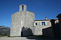
Saint-Jean-Baptiste church

