Saint-Bauzille-de-Montmel
|
Saint-Bauzille-de-Montmel Sant Bausèli de Montmèu |
||
|---|---|---|

|
|
|
| region | Occitania | |
| Department | Herault | |
| Arrondissement | Lodève | |
| Canton | Saint-Gély-du-Fesc | |
| Community association | Grand Pic Saint Loup | |
| Coordinates | 43 ° 46 ′ N , 3 ° 57 ′ E | |
| height | 62-320 m | |
| surface | 21.52 km 2 | |
| Residents | 1,022 (January 1, 2017) | |
| Population density | 47 inhabitants / km 2 | |
| Post Code | 34160 | |
| INSEE code | 34242 | |
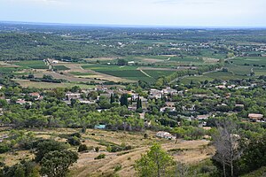
 View of Saint-Bauzille-de-Montmel |
||
Saint-Bauzille-de-Montmel ( Occitan : Sant Bausèli de Montmèu ) is a French commune with 1,022 inhabitants (as of January 1, 2017) in the Hérault department in the Occitanie region . It belongs to the arrondissement of Lodève and the canton of Saint-Gély-du-Fesc (until 2015: canton of Les Matelles ). The inhabitants are called Saint-Bauzillois .
geography
Saint-Bauzille-de-Montmel is located about 18 kilometers north-northeast of Montpellier . Saint-Bauzille-de-Montmel is surrounded by the neighboring communities Vacquières in the north, Carnas in the northeast, Galargues in the east and northeast, Buzignargues in the east, Montaud in the south, Saint-Mathieu-de-Tréviers in the west and southwest, Sainte-Croix- de-Quintillargues in the west and Fontanès in the west and north-west.
Population development
| Population development | ||||||||
|---|---|---|---|---|---|---|---|---|
| year | 1962 | 1968 | 1975 | 1982 | 1990 | 1999 | 2006 | 2017 |
| Residents | 330 | 354 | 370 | 456 | 479 | 734 | 883 | 1022 |
| Sources: Cassini and INSEE | ||||||||
Attractions
- Saint-Bauzille church from 1870
- protestant church
- old Saint-Germain church in the hamlet of Fournes

