Lac du Salagou
| Lac du Salagou | |||||
|---|---|---|---|---|---|
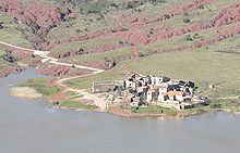
| The “ruffes” of Lac du Salagou | |||||
|
|||||
|
|
|||||
| Coordinates | 43 ° 39 '33 " N , 3 ° 22' 5" E | ||||
| Data on the structure | |||||
| Lock type: | Gravity dam | ||||
| Construction time: | 1964-1969 | ||||
| Height of the barrier structure : | 60 m | ||||
| Crown length: | 357 m | ||||
| Data on the reservoir | |||||
| Altitude (at congestion destination ) | 140 m | ||||
| Water surface | 7 km² | ||||
| Storage space | 102 million m³ | ||||
The French Lac du Salagou is a reservoir of the Salagou River . It is located in the middle of the Hérault department , in the Salagou river, which, after leaving the lake, flows into the Lergue (or L'Ergue) river, which in turn flows into the Herault . The surface of the reservoir is on average 140 m . The lake has an average temperature of 28 ° C in summer. The lake is dominated by 300 m high mountains and plateaus in the east and the 407 m high Carols in the west. The landscape around the lake is strongly shaped by the geological conditions, which create a very characteristic atmosphere .
The lake is a tourist destination, especially in the summer months, and can be easily reached by country roads, especially since the opening of the A75 motorway. Tourism and viticulture are of particular economic importance for the Lac du Salagou area. There are extensive vineyards, especially in the south around Liausson and Octon. In some places olives are grown.
Construction and use of the reservoir
First plans for the construction of a reservoir took place at the end of the 1950s. The reservoir was not only intended to serve as flood protection by catching the tributaries of the Salagou and its tributaries into the Herault. The main plan was to create a water reservoir to irrigate orchards. The reason for this was the overproduction of wine in the area, so that other forms of cultivation should be introduced.
A heavyweight dam was designed with a core of basalt blocks, which was provided with a bitumen- concrete seal on the lake side . The wall is 60 m high and has a crown length of 357 m. With a final dam height of 139 m , the reservoir can hold a volume of 102 million m 3 , the lake surface is then about 700 hectares . A small power station was built in front of the wall and has been in operation since 1986.
Work on the dam wall at the favorable bottleneck between the Germane plateau and the l'Auverne plateau began in 1964, so that the damming began in 1969. Due to severe storms, the water inflow was so great that the reservoir was filled within a few months. Parts of the municipalities of Clermont-l'Hérault in the east, Liausson in the south, Octon in the west and Celles in the north are sunk in the lake . Likewise, Route nationale 9 , which was relocated to a northern route, was interrupted by the reservoir .
After it became clear that the soon-to-be-built tourist facilities would be far away from the water if the lake was used intensively for irrigation, the irrigation project was abandoned, so that the lake has been used almost exclusively for tourism ever since.
Part of the lake is also used by the fire-fighting planes for fighting forest fires, which take in water here at low altitude.
geology
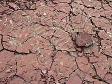
The Lac du Salagou is located in the so-called Lodève Basin (Bassin de Lodève), a relatively small (10 × 25 km) fossil sedimentary basin , which is named after the small town of Lodève northwest of the lake. Note the deep red color of there pending deposits, fine-grained, foliated secreting siliciclastic sediments , which are called because of their color "ruffes". They are very prone to erosion and form undulating badlands with pillow-like hills, deep erosion channels and narrow canyons.
During the Carboniferous , about 350 million years ago, a mountain range, the Variscan Mountains, unfolded . In the vicinity of the Lodève basin, the Massif Central , the Cevennes and the Montagne Noire are geological testimonies to this mountain formation. During the uplift of the Variscan Mountains and afterwards their erosion took place , and huge amounts of rubble were transported by rivers into seas and lakes. The rocks that emerged from the rubble that was deposited relatively close to the mountains can be viewed as stratigraphic equivalents of the Rotliegend of Central Europe.
One of the deposit areas of such Rotliegend equivalents is the Lodéve Basin. It sank into the subsoil at the end of the Carboniferous due to a fault on the southern edge of what is now the Lodève Basin and took up large amounts of erosion debris. The preferred lowering of the basement on only one side of the basin is generally referred to as a half-ditch . Due to this geological structure, the youngest layers of the basin filling bite out directly on the southern edge of today's basin and the oldest on the northern edge.
The layers in the northern part of the basin, immediately south of Lodève, were deposited at the end of the Carboniferous and in the early Permian (“ Autunia ”, Usclas-Loiras Formation) and are rich in plant fossils . The Younger Permian terrain to the south (“ Saxono - Thuringia ”, Viala-Rabejac Formation and Salagou Formation) seems to have been deposited continuously in shallow waters, in Playa end lakes or the like. In the meantime, these waters often fell dry. Dry cracks , ripple marks and even fossil raindrops have been handed down on numerous strata. The strata of the Salagou Formation show fossilized footsteps and tracks from vertebrates , especially those from early amniotes . They belong to the trace genera Brontopus , Dimetropus , Macrochelichnus and Paranomodontipus and can be viewed as a geological natural monument near La Lieude in the Salagou valley southwest of the reservoir. After the Salagou formation was deposited, the Lodève basin subsided. However, larger areas of the earth's crust continued to sink slowly in what is now France and so, in the vicinity of the Massif Central, extensive layers of the Triassic , Jura and Lower Cretaceous were deposited in a shallow sea. The sedimentary rocks of the early Triassic are still terrestrial and more similar to those of the Permian (equivalents of the red sandstone of Central Europe). Chirotherium and traces of other precursors of the dinosaurs have been handed down on the strata of these early Triassic rocks. Marine Mesozoic rocks are preserved today in the mighty escarpments of the Larzac in the north of Lodéve and in the jagged peaks of the Montagne de Liausson ( dolomite of the Lower Jurassic ), which tower over the southern bank of the Lac du Salagou. In the Lodéve Basin, the contact between the permocarbonic rocks and the overlying deposits of the Mesozoic Era is formed as a discordance.
The uplift of the Pyrenees in the Tertiary finally caused numerous faults and thrusts , so that the Paleozoic rocks of the eastern Montagne Noire were lifted and are now at the surface of the earth at the same height as the younger rocks of the basin and its surroundings.
The tension in the crust caused by the uplift of the Pyrenees also resulted in brisk volcanic activity in the northern foreland . This is how the long chain of the Escandorgue was created 3 to 1.5 million years ago , in which volcanoes discharged in explosive eruptions, leaving behind layers of ash and lava flows made of basalt . The volcanoes of St. Amand and Brenas, about 5 km to the west, were decisive for the area around today's Lac du Salagou. From there, lava flows to the east almost to Clermont l'Hérault, at the same time numerous intrusions of basalt formed.
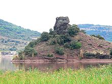
Today three weathered basalt hills protrude as islands or peninsulas from the reservoir. Lava bombs that have been thrown up are scattered on the red sediments in some places. Where the basalts have spread out as a blanket up to 60 m thick, they form cliff-rimmed hills with flat surfaces and steep slopes, such as the Germane and l'Auverne plateaus directly to the east and north of the lake. In many places, basalt columns have been deposited from the solidifying lava that can reach heights of several meters.
Other sights
Various old buildings, among them, testify to the long settlement of the area around Lac du Salagou
- the Romanesque chapel of Saint-Pierre de Mérifons
- the mill of Salasc
- the stone huts on the Plateau de l'Auverne
- the ruins of the Castellas de Malavielle
Panoramic images of the Lac du Salagou
Individual evidence
- ↑ a b La création du lac , by George Suche (French) . Retrieved April 27, 2008
- ↑ Lac du Salagou: le barrage , Découvrir l'Hérault, Hérault Tourisme (French) ( Memento of the original of May 13, 2008 in the Internet Archive ) Info: The archive link was inserted automatically and has not yet been checked. Please check the original and archive link according to the instructions and then remove this notice. . Retrieved April 27, 2008
- ↑ Par millions d'années ... , Salagou - Land des ruffe, by George Suche (French) . Retrieved April 27, 2008
- ↑ Stephane Pochat, Jean van den Driessche, Valerie Mouton, Francois Guillocheau: Identification of Permian palaeowind direction from wave-dominated lacustrine sediments (Lodève Basin, France). Sedimentology. Vol. 52, 2005, pp. 809-825, doi: 10.1111 / j.1365-3091.2005.00697.x
- ↑ Hartmut Haubold: Tetrapod tracks from the Permian - state of knowledge and progress 2000. Hallesches Jahrbuch für Geoswissenschaften. Vol. B 22, 2000, pp. 1-16
- ↑ Par millions d'années ... , Reptile footprints at La Lieude, photo by George Suche . Retrieved April 27, 2008
literature
- Jean Dercourt: Géologie et géodynamique de la France: Outre-mer et européenne , Dunod, Collection: Sciences Sup, 2002, ISBN 2-10-006459-2
- Jean-Claude Bousquet: Géologie du Languedoc-Roussillon , Montpellier 1997
- Bernard Gèze: Languedoc méditerranéen, Montagne Noire , Guides géologiques régionaux, 191 pages, Masson, Paris 1979. ISBN 2-225-64120-X
- Bedarieux , Carte géologique détaille de la France 1: 80.000, p. 232, Bureau des Récherches géologiques et minières, Orléans-la-Source, 3rd edition 1971. Explanations by Bernard Gèze
Web links
- Georges Souche and Max Rouquette: Le Lac du Salagou au fil des saisons (French)
- B. Halleux: Geologique sort: de Bédarieux au Salagou. , Geological excursion to Lac du Salagou (French)
- Dieter J. Baumgart: The Lac du Salagou - how it became what it is


