Vis (river)
| Vis | ||
|
Weir at Saint-Laurent-le-Minier |
||
| Data | ||
| Water code | FR : Y2030500 | |
| location | France , Occitania region | |
| River system | Herault | |
| Drain over | Hérault → Mediterranean | |
| source | in the municipality of Arrigas 44 ° 1 '8 " N , 3 ° 28' 29" O |
|
| Source height | approx. 1300 m | |
| muzzle | near Ganges in the Hérault coordinates: 43 ° 56 '22 " N , 3 ° 41' 23" E 43 ° 56 '22 " N , 3 ° 41' 23" E |
|
| Mouth height | approx. 143 m | |
| Height difference | approx. 1157 m | |
| Bottom slope | approx. 20 ‰ | |
| length | 58 km | |
| Catchment area | 481 km² | |
| Drain at the Saint-Laurent-le-Minier gauge |
NNQ (1962) MQ HHQ (1982) |
1 m³ / s 10 m³ / s 542 m³ / s |
| Right tributaries | Virusque | |
|
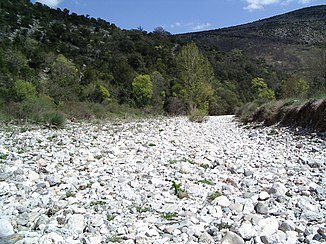
dry vis at Vissec |
||
The Vis is a river in France that runs in the Occitania region .
Course and characteristics

The Vis rises in the Cevennes National Park , near the Col de l'Homme Mort , in the municipality of Arrigas . Initially, it drains in a south-westerly direction, but then turns to the northeast and flows into the Hérault as a right tributary after 58 kilometers above Ganges . On its way, it crosses the Gard and Hérault departments .
In the upper section of the river, the river bed of the Vis is dry below the town of Alzon, giving the town of Vissec ("dry Vis") its name. At the Résurgence de la Vis , its water emerges as a strong karst spring after it has passed under the adjacent karst plateaus such as the southern Causse du Larzac . The huge basin of the Cirque de Navacelles with the town of Saint-Maurice-Navacelles is impressive. Here the Vis has broken a forced meander and shortens its course as a waterfall. There and at the Résurgence de la Vis there are restored mills. Even today, the water-rich and sloping river is used in smaller hydropower plants to generate energy. Because of its picturesque, often gorge-like valley and its popularity as a bathing water, the Vis is very popular.
The mean water flow is 10 m³ / s. The mean monthly discharge fluctuates between under 3 m³ / s in August and over 17 m³ / s in January. The extreme runoff can be well over 500 m³ / s.
Resurgence de la Vis
The karst spring Résurgence de la Vis (Eng. Re-emergence of the Vis) or also called Source de la Foux , is located west of Vissec (Lage) . There the river Vis re-emerges, which previously seeped into the karst ground in the upper valley. The strong spring pours out an average of 5260 l / s. The mean monthly minimum flow was measured in August 2002 with 1700 l / s and the maximum flow in December 2003 with 25,500 l / s. In extreme cases, as on November 24, 2003, the current discharge can rise to 245,000 l / s. The source can only be reached on foot. Below the Résurgence de la Vis , the mills (Moulins de la Foux) were built in 1097 and razed in 1629 .
Places on the river
(Order in flow direction)
See also
Web links
Traffic report at kajaktour.de
Individual evidence
- ↑ a b geoportail.fr (1: 16,000)
- ↑ a b c The information on the length of the river is based on the information about the Vis from SANDRE (French), accessed on April 1, 2011, rounded to full kilometers.
- ↑ hydro.eaufrance.fr (station: Y2035010 , option: Synthèse )


