Caux (Hérault)
| Caux | ||
|---|---|---|

|
|
|
| region | Occitania | |
| Department | Herault | |
| Arrondissement | Beziers | |
| Canton | Pézenas | |
| Community association | Hérault Méditerranée | |
| Coordinates | 43 ° 30 ' N , 3 ° 22' E | |
| height | 27-166 m | |
| surface | 24.84 km 2 | |
| Residents | 2,560 (January 1, 2017) | |
| Population density | 103 inhabitants / km 2 | |
| Post Code | 34720 | |
| INSEE code | 34063 | |
| Website | membres.lycos.fr | |

|
||
Caux (the name comes from chaux = lime) is a circular French commune with 2560 inhabitants (as of January 1, 2017) in the Hérault department in the Occitanie region .
history
The historic market town of Caux is a Languedoc jewel. The name of the village, Alode de Caucio , is first mentioned in a text from 961. Caux was founded as a Circulade , a circular arrangement of structures that enabled defense in the turbulent history of the region on all sides. During the Hundred Years War , Caux remained intact due to its fortifications, but in 1579 it was captured by a ruse of the besiegers during the Huguenot Wars . The village was burned down and the castle destroyed. The reconstruction of the village lasted until the 17th century and it was now connected to neighboring Pézenas (seven kilometers) via a new road . In 1909 Caux was electrified and a year later the first telephone came to town. Today, Caux offers its visitors a medieval church, archaeological exhibitions and all the necessary services of a modern holiday destination. Caux is known for its excellent vineyards.
Population development
| year | 1962 | 1968 | 1975 | 1982 | 1990 | 1999 | 2006 | 2017 |
| Residents | 1774 | 1711 | 1546 | 1578 | 1709 | 1968 | 2463 | 2560 |
| Sources: Cassini and INSEE | ||||||||
Attractions
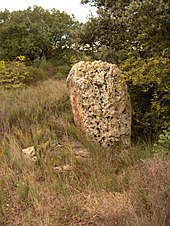
- Menhir of Peyreficade (= the planted stone).
- Les Capitelles , huts made of dry stone.
- Remains of limestone quarries.
- Église Saint-Gervais et Protais and its portal tower.
Personalities
- François Lamathe Bedos de Celles de Salelles (1709–1779), known as Dom Bedos de Celles , Benedictine monk , organist and organ builder .
- General Jean-Jacques Causse (1751–1796), Brigadier General who served under Napoléon Bonaparte .

