
Castelnau-de-Guers
|
Castelnau-de-Guers Castèlnòu de Guèrs |
||
|---|---|---|
.svg)
|
|
|
| region | Occitania | |
| Department | Herault | |
| Arrondissement | Beziers | |
| Canton | Pézenas | |
| Community association | Hérault Méditerranée | |
| Coordinates | 43 ° 26 ' N , 3 ° 26' E | |
| height | 1–105 m | |
| surface | 22.51 km 2 | |
| Residents | 1,197 (January 1, 2017) | |
| Population density | 53 inhabitants / km 2 | |
| Post Code | 34120 | |
| INSEE code | 34056 | |
| Website | http://www.castelnau-de-guers.com/village.php | |
 View of Castelnau-de-Guers |
||

Castelnau-de-Guers ( Occitan : Castèlnòu de Guèrs ) is a southern French municipality with 1,197 inhabitants (as of January 1, 2017) in the Hérault department in the Occitanie region . The municipality is part of the arrondissement of Béziers and the canton of Pézenas (until 2015: canton of Florensac ). The inhabitants are called Castelnaulais .
geography
Castelnau-de-Guers is located near the Mediterranean lagoon Étang de Thau about 20 kilometers east-northeast of Béziers . Castelnau-de-Guers is surrounded by the neighboring communities of Pézenas in the north and west, Aumes in the north, Montagnac in the east and northeast, Pinet in the south and southeast and Florensac in the south.
population
Population development
| year | 1962 | 1968 | 1975 | 1982 | 1990 | 1999 | 2006 | 2017 |
| Residents | 831 | 837 | 827 | 886 | 876 | 889 | 1 010 | 1197 |
| Sources: Cassini and INSEE | ||||||||
Personalities
- Michel Christol (* 1942), ancient historian and epigraphist
Attractions
- Saint-Sulpice church
- Chapel ruin Saint-Antoine
- Chapel of Saint Nicolas in Talpuciac
- Castelnau Castle with chapel, built at the beginning of the 20th century
- Libouriac Castle, built 1883–1885, winery, since 1995 Monument historique
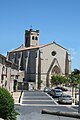
Saint-Sulpice church

Saint-Antoine chapel
Castelnau Castle


Web links
Commons : Castelnau-de-Guers - collection of images, videos and audio files