
Servian
| Servian | ||
|---|---|---|
.svg)
|
|
|
| region | Occitania | |
| Department | Herault | |
| Arrondissement | Beziers | |
| Canton | Béziers-3 | |
| Community association | Béziers Méditerranée | |
| Coordinates | 43 ° 26 ' N , 3 ° 18' E | |
| height | 19-103 m | |
| surface | 40.61 km 2 | |
| Residents | 4,937 (January 1, 2017) | |
| Population density | 122 inhabitants / km 2 | |
| Post Code | 34290 | |
| INSEE code | 34300 | |
| Website | http://www.ville-servian.fr/ | |
 Servian City Hall |
||

Servian ( Occitan : Cervian ) is a French commune with 4937 inhabitants (as of January 1, 2017) in the Hérault department in the Occitanie region . Servian belongs to the arrondissement of Béziers and the canton of Béziers-3 .
geography

Servian is about eight kilometers northeast of Béziers on the Thongue , a tributary of the Hérault . Servian is surrounded by the neighboring communities of Coulobres and Abeilhan in the north, Alignan-du-Vent and Tourbes in the northeast, Valros in the east, Montblanc in the southeast, Béziers in the south, Boujan-sur-Libron in the southwest, Bassan in the west and Espondeilhan in the northwest.
The A75 autoroute runs through the municipality .
Population development
| year | 1962 | 1968 | 1975 | 1982 | 1990 | 1999 | 2006 | 2017 |
| Residents | 2930 | 3053 | 2832 | 2752 | 3056 | 3355 | 3962 | 4937 |
Attractions
- Parrocchial church from the 12th century
- Ruins of the former fortifications
- Sainte-Rose Castle
- 17th century Thongue Bridge
- Saint-Adrien garden

Parish Church of Servian
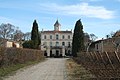
Sainte-Rose Castle


Personalities
- Jean Bouillet (1690–1777), medic
- Jean Aubagnac (1854–1939), painter
- Robert Monclar (1930–2012), basketball player
- Hans-Reinhard Lehmphul (1938–2009), painter, lived in Servian for a long time
Parish partnership
There is a partnership with the German municipality of Bad Wimpfen in Baden-Württemberg .