
Colombières-sur-Orb
|
Colombières-sur-Orb Colombièiras d'Òrb |
||
|---|---|---|
.svg)
|
|
|
| region | Occitania | |
| Department | Herault | |
| Arrondissement | Beziers | |
| Canton | Saint-Pons-de-Thomières | |
| Community association | Minervois Saint-Ponais Orb-Jaur | |
| Coordinates | 43 ° 35 ' N , 3 ° 1' E | |
| height | 132-1,008 m | |
| surface | 8.11 km 2 | |
| Residents | 479 (January 1, 2017) | |
| Population density | 59 inhabitants / km 2 | |
| Post Code | 34390 | |
| INSEE code | 34080 | |

Colombières-sur-Orb ( Occitan : Colombièiras d'Òrb ) is a place and a municipality in the south of France with 479 inhabitants (as of January 1, 2017) in the Hérault department in the Occitania region . The municipality belongs to the arrondissement of Béziers and the canton of Saint-Pons-de-Thomières (until 2015: canton of Olargues ). The inhabitants are called Colombiérois .
location
Colombières-sur-Orb is located about 31 kilometers north-north-west of Béziers am Orb . Colombières-sur-Orb is surrounded by the neighboring communities Rosis in the north, Combes in the east and northeast, Le Poujols-sur-Orb in the east, Les Aires in the south and southeast, Mons in the southwest and Saint-Martin-de-l'Arçon in the West.
Population development
| year | 1962 | 1968 | 1975 | 1982 | 1990 | 1999 | 2006 | 2017 |
| Residents | 273 | 266 | 270 | 339 | 397 | 417 | 444 | 479 |
| Sources: Cassini and INSEE | ||||||||
Attractions
- Saint-Pierre church
- Chapel of Sainte-Colombe
- Tower with a square base from the 14th century
- Colombières castle from the 17th century

Saint-Pierre church

Chapel of Sainte-Colombe
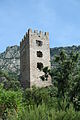
square tower

Colombières Castle


Personalities
- Jean-Claude Carrière (* 1931), writer