
Cabrerolles
|
Cabrerolles Cabrairòlas |
||
|---|---|---|
.svg)
|
|
|
| region | Occitania | |
| Department | Herault | |
| Arrondissement | Beziers | |
| Canton | Cazouls-lès-Beziers | |
| Community association | Les Avant-Monts | |
| Coordinates | 43 ° 33 ' N , 3 ° 8' E | |
| height | 134-705 m | |
| surface | 28.68 km 2 | |
| Residents | 335 (January 1, 2017) | |
| Population density | 12 inhabitants / km 2 | |
| Post Code | 34480 | |
| INSEE code | 34044 | |
| Website | http://www.cabrerolles.fr/ | |

Cabrerolles ( Occitan: Cabrairòlas ) is a French commune with 335 inhabitants (as of January 1, 2017) in the Hérault department in the Occitanie region . It belongs to the arrondissement of Béziers and the canton of Cazouls-lès-Béziers (until 2015: canton of Murviel-lès-Béziers ). The inhabitants are called Cabrerollais .
geography
Cabrerolles is about 15 kilometers north of Béziers on the Libron . Cabrerolles is surrounded by the neighboring communities of Les Aires in the north and north-west, Hérépain in the north and north-east, Faugères in the east and north-east, Caussiniojouls in the east, Laurens in the east and south-east, Autignac in the south and south-east, Murviel-lès-Béziers in the south and Saint -Nazaire-de-Ladarez to the west.
Population development
| year | 1962 | 1968 | 1975 | 1982 | 1990 | 1999 | 2006 | 2017 |
| Residents | 293 | 284 | 256 | 255 | 293 | 270 | 324 | 335 |
| Sources: Cassini and INSEE | ||||||||
Attractions
- Saint-Amand church
- Cabrerolles Castle, built in the early 12th century, Monument historique
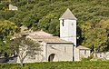
Saint-Amand church

Cabrerolles Castle


economy
The wines grown in the village are included in the Faugères wine-growing region .