
Premian
|
Prémian Prumian |
||
|---|---|---|
.svg)
|
|
|
| region | Occitania | |
| Department | Herault | |
| Arrondissement | Beziers | |
| Canton | Saint-Pons-de-Thomières | |
| Community association | Minervois Saint-Ponais Orb-Jaur | |
| Coordinates | 43 ° 32 ′ N , 2 ° 50 ′ E | |
| height | 218-1,111 m | |
| surface | 16.69 km 2 | |
| Residents | 518 (January 1, 2017) | |
| Population density | 31 inhabitants / km 2 | |
| Post Code | 34390 | |
| INSEE code | 34219 | |
| Website | http://premian.fr/ | |
 Town Hall (Mairie) of Prémian |
||

Prémian ( Occitan : Prumian ) is a place and a municipality in the south of France with 518 inhabitants (as of January 1, 2017) in the Hérault department in the Occitania region . The municipality belongs to the arrondissement of Béziers and the canton of Saint-Pons-de-Thomières (until 2015: canton of Olargues ). The inhabitants are called Prémianais .
location
Prémian is about 37 kilometers northwest of Béziers am Jaur . In the north-west is the lake of Vézoles. Prémian is surrounded by the neighboring communities Fraisse-sur-Agout in the north, Saint-Étienne-d'Albagnan in the east and Riols in the south and west and north-west.
Population development
| year | 1962 | 1968 | 1975 | 1982 | 1990 | 1999 | 2006 | 2013 |
| Residents | 406 | 354 | 347 | 378 | 407 | 405 | 491 | 544 |
| Source: Cassini and INSEE | ||||||||
Attractions
- Church of La Caminade
- Vézoles waterfalls
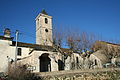
Church of La Caminade

Vézoles waterfalls

Lake of Vézoles


Web links
Commons : Prémian - collection of images, videos and audio files