La Salvetat-sur-Agout
| La Salvetat-sur-Agout | ||
|---|---|---|

|
|
|
| region | Occitania | |
| Department | Herault | |
| Arrondissement | Beziers | |
| Canton | Saint-Pons-de-Thomières | |
| Community association | Monts de Lacaune and Montagne du Haut Languedoc | |
| Coordinates | 43 ° 25 ′ N , 3 ° 22 ′ E | |
| height | 663–1,087 m | |
| surface | 87.55 km 2 | |
| Residents | 1,141 (January 1, 2017) | |
| Population density | 13 inhabitants / km 2 | |
| Post Code | 34330 | |
| INSEE code | 34293 | |
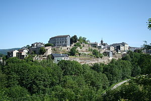
 View of La Salvetat-sur-Agout |
||
La Salvetat-sur-Agout is a southern French municipality with 1,141 inhabitants (as of January 1, 2017) in the Hérault department in the Occitania region . The municipality belongs to the arrondissement of Béziers and the canton of Saint-Pons-de-Thomières (until 2015: canton of La Salvetat-sur-Agout ). The inhabitants are called Salvetois .
location
La Salvetat-sur-Agout is located about 35 kilometers northwest of Béziers am Agout , which is dammed up here to form the Lac de la Raviège and is used for water sports. La Salvetat-sur-Agout is surrounded by the neighboring communities of Lacaune in the north, Nages in the northeast, Fraisse-sur-Agout in the east, Riols in the southeast, Le Soulié in the south, Anglès in the southwest and Lamontélarié in the west.
The Via Tolosana , one of the four historical " Paths of the Pilgrims of St. James in France " , runs through the municipality .
Population development
| year | 1962 | 1968 | 1975 | 1982 | 1990 | 1999 | 2006 | 2017 |
| Residents | 1532 | 1361 | 1115 | 1174 | 1153 | 1118 | 1194 | 1141 |
| Sources: Cassini and INSEE | ||||||||
Attractions
- Saint-Etienne church in La Salvetat, built in the 15th century
- Old Saint-Etienne church in the locality of Saint-Etienne-de-Cavall
- Bridge over the Vèbre, monument historique since 1964


