Anglès (Tarn)
| Anglès | ||
|---|---|---|

|
|
|
| region | Occitania | |
| Department | Camouflage | |
| Arrondissement | Castres | |
| Canton | Les Hautes Terres d'Oc | |
| Community association | Monts de Lacaune and Montagne du Haut Languedoc | |
| Coordinates | 43 ° 34 ′ N , 2 ° 34 ′ E | |
| height | 358-967 m | |
| surface | 85.62 km 2 | |
| Residents | 508 (January 1, 2017) | |
| Population density | 6 inhabitants / km 2 | |
| Post Code | 81160 | |
| INSEE code | 81014 | |
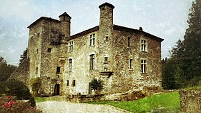
 Anglès - town view |
||
Anglès is a place and a municipality in the south of France with 508 inhabitants (as of January 1, 2017) in the wider area of Albi in the Tarn department in the Occitania region .
location
Anglès is located in the cultural landscape of the Albigeois only approx. 70 km (driving distance) southeast of Albi in the southwestern foothills of the Cevennes at an altitude of approx. 750 m above sea level. d. M. The climate is temperate; Rain falls all year round.
Population development
| year | 1800 | 1851 | 1901 | 1954 | 1999 | 2014 |
| Residents | 2,562 | 2,861 | 1,983 | 964 | 563 | 519 |
The continuous decline in the number of inhabitants since the middle of the 19th century is essentially due to the mechanization of agriculture and the associated loss of jobs.
economy
The inhabitants of the large community lived for centuries as self-sufficient farmers and livestock (sheep, goats). Forestry and tourism are also important today.
history
After the end of the Albigensian Wars (1209-1229) and the annexation of the County of Toulouse (1271), Anglès (or the Castrum de Angulis ) belonged to the diocese of Saint-Pons-de-Thomières . During the Huguenot Wars (1562–1598), several parish churches in today's parish were destroyed.
Attractions
- The Porte Bas city gate, which was renovated in the 17th century, is the only remaining part of the former city fortifications ( remparts ); it was declared a monument historique in 1927 .
- The former landmark of the place, an approx. 200-year-old chestnut tree in the center of the village, fell victim to a cold spell of several days with day and night frosts in the winter of 2012.
- A parish church was probably built in the Middle Ages; however, it was largely destroyed in the religiously motivated disputes of the 16th century. Its current condition corresponds to that of a comprehensive renovation at the beginning of the 19th century.
- The place, located in the southwestern foothills of the Cevennes , has had a small Protestant church ( temple ) since 1819 .
' outside'
- The church of the hamlet of La Souque , located about eight kilometers to the southeast and built in the late 19th century in the neo-Gothic style , has an apse made of natural stones. The baroque altar inside and its altarpiece were built in the 17th and 18th centuries. Century.
- The Château de Campan ( 43 ° 28 ′ 37.2 ″ N , 2 ° 36 ′ 38 ″ E ), located about ten kilometers south of the town and dominating the valley of the Thoré river , was probably built between the 11th and 13th centuries; However, its current condition with numerous cross-frame windows essentially corresponds to the renovations of the 16th / 17th century. Century. The privately owned building was recognized as a Monument historique in 1961 .
literature
- Jean Aymeric: Anglès et son terroir. Ferrières 1988, ISBN 978-2-86888-021-5 .
Web links
Individual evidence
- ↑ Anglès - Map with altitude information
- ↑ Albi / Anglès - climate tables
- ↑ Anglès - history etc.
- ^ Anglès - Porte Bas in the Base Mérimée of the French Ministry of Culture (French)
- ↑ Anglès Church
- ↑ Anglès - Château de Campan in the Base Mérimée of the French Ministry of Culture (French)

