Belcastel (Tarn)
| Belcastel | ||
|---|---|---|

|
|
|
| region | Occitania | |
| Department | Camouflage | |
| Arrondissement | Castres | |
| Canton | Lavaur Cocagne | |
| Community association | Stealth agout | |
| Coordinates | 43 ° 39 ′ N , 1 ° 45 ′ E | |
| height | 173-271 m | |
| surface | 10.81 km 2 | |
| Residents | 237 (January 1, 2017) | |
| Population density | 22 inhabitants / km 2 | |
| Post Code | 81500 | |
| INSEE code | 81025 | |
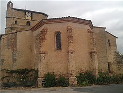
 Belcastel Town Hall |
||
Belcastel is a French commune with 237 inhabitants (as of January 1, 2017) in the Tarn department in the Occitanie region . It belongs to the canton of Lavaur Cocagne and the Arrondissement of Castres .
It borders on Verfeil to the north-west, Lavaur to the north and north- east, Viviers-lès-Lavaur to the south-east, Bannières to the south, Montcabrier to the south-west and Teulat to the west .
Population development
| year | 1962 | 1968 | 1975 | 1982 | 1990 | 1999 | 2007 | 2015 | ||||
|---|---|---|---|---|---|---|---|---|---|---|---|---|
| Residents | 227 | 221 | 182 | 167 | 181 | 176 | 189 | 221 | ||||
| Source: Cassini and INSEE | ||||||||||||
Attractions
- Saint-Etienne church with parts from the 16th century - Monument historique
- Lavoir (wash house)
- several wayside crosses on the D28 and in the village center
Web links
Commons : Belcastel - Collection of pictures, videos and audio files
Individual evidence
- ↑ Entry no. PA00095488 in the Base Mérimée of the French Ministry of Culture (French)

